1
Linkside Gardens, Enfield
Linkside Gardens as seen from Links Side.
Image: © Christine Matthews
Taken: 7 Oct 2008
0.02 miles
2
Parade of Shops, Links Side, Enfield
Looking across from the Jolly Farmers towards the small parade of shops, showing the George V pillar box
Image], with the parking area and service road which leads to Bincote Road. The corner shop is now a florist, but for many years this shop was a DIY store selling paints and wallpapers at very competitive prices.
Image: © Christine Matthews
Taken: 7 Oct 2008
0.02 miles
3
Links Side, Enfield
Looking up Links Side towards the Enfield Road (A110), with the parade of shops and postbox.
Image: © Christine Matthews
Taken: 7 Oct 2008
0.04 miles
4
George V postbox and telephone box on Enfield Road
Outside the former post office.
Postbox No. EN2 17.
See
Image] for context.
Image: © JThomas
Taken: 23 Apr 2016
0.04 miles
5
Shops and former Post Office on Enfield Road
Showing position of Postbox No. EN2 17.
See
Image] for postbox.
Image: © JThomas
Taken: 23 Apr 2016
0.04 miles
6
Enfield: Jolly Farmers Public House
A McMullen's lorry is making a delivery to this tied house which is on the A110 Enfield Road at its junction with Links Side. McMullen's Brewery http://www.mcmullens.co.uk/ is in Hertford and the pub's website is here http://www.the-jolly-farmers.co.uk/home.htm
Image: © Nigel Cox
Taken: 17 Jan 2008
0.04 miles
7
Enfield: London sheep
Are these beasties the closest sheep to the centre of London? The paddock is 16 kilometres as the crow flies from Charing Cross.
Image: © Nigel Cox
Taken: 17 Jan 2008
0.04 miles
8
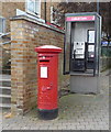
George V Pillar Box, Links Side, Enfield
There is a small parade of shops with a service road at the end of Links Side before you reach the Enfield Road (A110). Near a small car parking area is this George V pillar box. There used to be a small post office in the parade, but this closed some time ago. There is also a modern style phone box behind the pillar box.
Image: © Christine Matthews
Taken: 7 Oct 2008
0.04 miles
9
Large Oak Tree on corner of Links Side, Enfield
On the corner of Links Side and the Enfield Road (A110) there is this large oak tree.
Image: © Christine Matthews
Taken: 7 Oct 2008
0.05 miles
10
Jolly Farmers Public House, Frog's Bottom, Enfield
Jolly Farmer's Public House in the Enfield Road in an area called Frog's Bottom. Once over the bridge taking the A110 across Salmon's Brook towards Enfield, the road name changes to Slades Hill.
Image: © Christine Matthews
Taken: 2 Mar 2007
0.05 miles


