IMAGES TAKEN NEAR TO
Gladbeck Way, ENFIELD, EN2 7HR
Introduction
This page details the photographs taken nearby to Gladbeck Way, EN2 7HR by members of the Geograph project.
The Geograph project started in 2005 with the aim of publishing, organising and preserving representative images for every square kilometre of Great Britain, Ireland and the Isle of Man.

There are currently over 7.5m images from over14,400 individuals and you can help contribute to the project by visiting https://www.geograph.org.uk
Image Map (Loading...)


Getting Data...Please wait
Leaflet Map data © OpenStreetMap
Images are licensed for reuse under creativecommons.org/licenses/by-sa/2.0
Notes
- Clicking on the map will re-center to the selected point.
- The higher the marker number, the further away the image location is from the centre of the postcode.
Image Listing (49 Images Found)
Images are licensed for reuse under creativecommons.org/licenses/by-sa/2.0
Image
Details
Distance
1
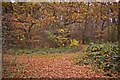
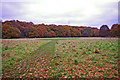
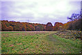
Woodland path, Cheyne Walk Open Space, London N21
Wonderful autumn colours with fallen leaves on the ground of this footpath through the wooded area of the Cheyne Walk Open Space.
Image: © Christine Matthews
Taken: 15 Nov 2008
0.10 miles
2
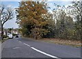
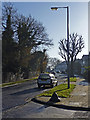
Old Park Avenue, Enfield
Bush Hill Park is on the right.
Image: © David Howard
Taken: 28 Nov 2021
0.11 miles
3
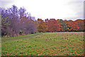
Cheyne Walk Open Space, London N21
Looking across the Cheyne Walk Open Space towards Enfield.
Image: © Christine Matthews
Taken: 15 Nov 2008
0.12 miles
4
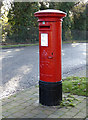
George V Pillar Box, Old Park Avenue, Enfield
George V pillar box not far from Old Park Grove. Image]
Image: © Christine Matthews
Taken: 7 Dec 2008
0.12 miles
5
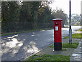
George V Pillar Box, Old Park Avenue, Enfield
Looking south down Old Park Avenue. Image] George V pillar box.
Image: © Christine Matthews
Taken: 7 Dec 2008
0.12 miles
6
Cheyne Walk Open Space, London N21
Looking south-east across the Cheyne Walk Open Space. The only evidence of civilisation that can be seen is the mobile phone mast.
Image: © Christine Matthews
Taken: 15 Nov 2008
0.13 miles
7
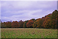
Cheyne Walk Open Space, London N21
Looking north-west across the Cheyne Walk Open Space, the spire of St Mary Magdalene in Windmill Hill can be seen in the centre of the image above the trees.
Image: © Christine Matthews
Taken: 15 Nov 2008
0.13 miles
8
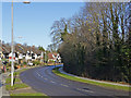
Old Park Avenue, Enfield
Looking north up Old Park Avenue from the corner of Old Park Grove.
Image: © Christine Matthews
Taken: 7 Dec 2008
0.14 miles
9
Old Park Avenue, Enfield
Looking south down Old Park Avenue from the corner of Old Park Grove.
Image: © Christine Matthews
Taken: 7 Dec 2008
0.14 miles
10
Cheyne Walk Open Space, London N21
Looking south-east across the Cheyne Walk Open space. Only evidence of human occupation is the mobile phone mast.
Image: © Christine Matthews
Taken: 15 Nov 2008
0.15 miles