IMAGES TAKEN NEAR TO
The Coppice, ENFIELD, EN2 7BY
Introduction
This page details the photographs taken nearby to The Coppice, EN2 7BY by members of the Geograph project.
The Geograph project started in 2005 with the aim of publishing, organising and preserving representative images for every square kilometre of Great Britain, Ireland and the Isle of Man.

There are currently over 7.5m images from over14,400 individuals and you can help contribute to the project by visiting https://www.geograph.org.uk
Image Map
Images are licensed for reuse under creativecommons.org/licenses/by-sa/2.0
Notes
- Clicking on the map will re-center to the selected point.
- The higher the marker number, the further away the image location is from the centre of the postcode.
Image Listing (124 Images Found)
Images are licensed for reuse under creativecommons.org/licenses/by-sa/2.0
Image
Details
Distance
1
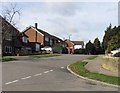
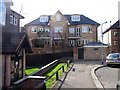
Hazelwood Drive into Old Park View, Enfield
Image: © John Salmon
Taken: 10 Mar 2007
0.02 miles
2
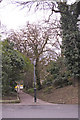
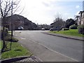
Footpath from Crescent Road to Old Park View, Enfield
Image: © Christine Matthews
Taken: 18 Mar 2008
0.05 miles
3
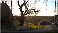
Entrance to Enfield Golf Club
The club was founded in 1893. Its main entrance is located on Old Park Road South.
Image: © Paul Bryan
Taken: 7 Jan 2018
0.06 miles
4
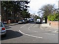
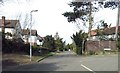
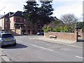
Crescent Road from Waverley Road, Enfield
Image: © John Salmon
Taken: 10 Mar 2007
0.07 miles
5
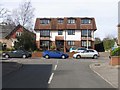
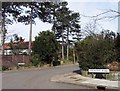
Corner of Waverley Road and Crescent Road, Enfield
Image: © John Salmon
Taken: 10 Mar 2007
0.08 miles
8
Vermont Close into Waverley Road, Enfield
Image: © John Salmon
Taken: 10 Mar 2007
0.09 miles
9
Waverley Road into Crescent Road, Enfield
Image: © John Salmon
Taken: 10 Mar 2007
0.11 miles
10
Crescent Road into Old Park Road, Enfield
Image: © John Salmon
Taken: 10 Mar 2007
0.11 miles