IMAGES TAKEN NEAR TO
Cooks Hole Road, ENFIELD, EN2 0UD
Introduction
This page details the photographs taken nearby to Cooks Hole Road, EN2 0UD by members of the Geograph project.
The Geograph project started in 2005 with the aim of publishing, organising and preserving representative images for every square kilometre of Great Britain, Ireland and the Isle of Man.

There are currently over 7.5m images from over14,400 individuals and you can help contribute to the project by visiting https://www.geograph.org.uk
Image Map
Images are licensed for reuse under creativecommons.org/licenses/by-sa/2.0
Notes
- Clicking on the map will re-center to the selected point.
- The higher the marker number, the further away the image location is from the centre of the postcode.
Image Listing (37 Images Found)
Images are licensed for reuse under creativecommons.org/licenses/by-sa/2.0
Image
Details
Distance
1
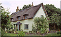
The Thatched Cottage, Cooks Hole Road, Enfield
Just off Hilly Fields, behind Lavender Hill Cemetery is this delightful thatched cottage.
Image: © Christine Matthews
Taken: Unknown
0.01 miles
2
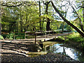
Bridge over Turkey Brook
Hilly Fields Park is across the bridge.
Image: © Robin Webster
Taken: 3 Nov 2012
0.10 miles
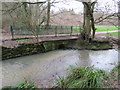
3
Bridge over Turkey Brook, near Enfield
A bridge carrying a path over Turkey Brook in Hilly Fields Park, near Enfield in the outer suburbs of north London. The path forms part of the London LOOP long distance footpath, and is also on the route of National Cycle Network route 12.
Image: © Malc McDonald
Taken: 22 Feb 2020
0.10 miles
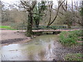
4
Bridge over a drain in Hilly Fields Park, near Enfield
A bridge carrying a path over a drainage channel in Hilly Fields Park, on the outer fringe of north London. The channel drains into Turkey Brook which flows in the foreground.
The path crossing the bridge is shared by pedestrians and cyclists. It is on the route of the London LOOP long distance footpath and also forms part of National Cycle Network route 12.
Image: © Malc McDonald
Taken: 22 Feb 2020
0.11 miles
5
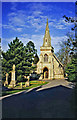
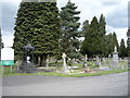
Chapel, Lavender Hill Cemetery, Enfield
The eastern Chapel at Lavender Hill Cemetery taken from just inside the entrance.
Image: © Christine Matthews
Taken: Unknown
0.17 miles
6
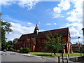
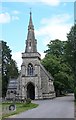
St Luke the Evangelist
Built 1899-1900. The architect was James Brooks who was responsible for many other churches, mostly in East London. The nave was completed in 1909 and a tower was planned but never realised.
Image: © Bikeboy
Taken: 16 Aug 2014
0.17 miles
7
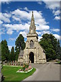
Chapel, Lavender Hill Cemetery
The eastern Chapel at Lavender Hill Cemetery. Compare with this much older view: Image
Image: © Chris Holifield
Taken: 11 Aug 2013
0.17 miles
8
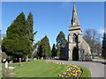
The Anglican chapel in Lavender Hill Cemetery
Lavender Hill Burial Board was set up in 1871 and opened the 9 acre Lavender Hill Cemetery in 1872, with two chapels, one Anglican and the other Nonconformist, as well as a stone lodge at the main entrance. Lavender Hill is so-called after the lavender that was once grown in this area. The cemetery was enlarged in 1897 by three acres, and has since been further enlarged. The western Nonconformist chapel is no longer in use and became a store.
Image: © Marathon
Taken: 15 Mar 2017
0.17 miles
10
Gordon Hill : cemetery chapel, Lavender Hill Cemetery
Grade II listed chapel. Architect: T.J. Hill. https://historicengland.org.uk/listing/the-list/list-entry/1358744
Image: © Jim Osley
Taken: 13 Jun 2020
0.17 miles