IMAGES TAKEN NEAR TO
Browning Road, ENFIELD, EN2 0HH
Introduction
This page details the photographs taken nearby to Browning Road, EN2 0HH by members of the Geograph project.
The Geograph project started in 2005 with the aim of publishing, organising and preserving representative images for every square kilometre of Great Britain, Ireland and the Isle of Man.

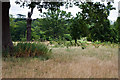
There are currently over 7.5m images from over14,400 individuals and you can help contribute to the project by visiting https://www.geograph.org.uk
Image Map (Loading...)


Getting Data...Please wait
Leaflet Map data © OpenStreetMap
Images are licensed for reuse under creativecommons.org/licenses/by-sa/2.0
Notes
- Clicking on the map will re-center to the selected point.
- The higher the marker number, the further away the image location is from the centre of the postcode.
Image Listing (103 Images Found)
Images are licensed for reuse under creativecommons.org/licenses/by-sa/2.0
Image
Details
Distance
1
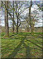
Hilly Fields Park, Phipps Hatch Lane, Enfield
Hilly Fields Park, Phipps Hatch Lane, looking towards Clay Hill.
Image: © Christine Matthews
Taken: 18 Mar 2007
0.07 miles
2
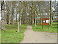
Hilly Fields Park, Phipps Hatch Lane, Enfield
Entrance to Hilly Fields Park from Phipps Hatch Lane.
Image: © Christine Matthews
Taken: 18 Mar 2007
0.08 miles
4
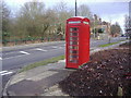
Phone box in Enfield
Corner of Clay Hill and Browning Road
Image: © David Howard
Taken: 11 Feb 2009
0.09 miles
5
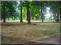
Hilly Fields Park
A view giving some idea of the mixed areas of the park, some allowed to grow wild whilst others are mown. The park is crossed by several tarmac'd paths suitable for pushing buggies, etc.
Image: © Martin Addison
Taken: 26 Jul 2010
0.09 miles
6
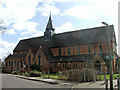
St Luke's, Phipps Hatch Lane, Enfield
St Luke's Church, Phipps Hatch Lane, opposite Hilly Fields Park.
Image: © Christine Matthews
Taken: 18 Mar 2007
0.10 miles
7

St Luke's, Phipps Hatch Lane, Enfield
St Luke's Church is on the corner of Phipps Hatch lane opposite Hilly Fields Park.
Image: © Christine Matthews
Taken: 18 Mar 2007
0.10 miles
8

St Luke's, Phipps Hatch Lane, Enfield
St Luke's as seen from Hilly Fields.
Image: © Christine Matthews
Taken: Unknown
0.11 miles
9

The LOOP crosses the road
This section of the London Loop footpath doubles as a cycleway, hence this safety island at a road crossing.
Image: © Des Blenkinsopp
Taken: 5 Jun 2014
0.11 miles
10
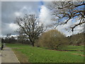
Hilly Fields Park
On the London Loop between Enfield Lock and Cockfosters, section 17 of the route. The London Loop (London Outer Orbital Path) is a 150-mile circular route and this section of it is 9.5 miles long. The London Loop is sometimes known as the M25 for walkers and it generally tends to follow parks, woodland and green open spaces.
Image: © Peter S
Taken: 29 Mar 2018
0.11 miles