IMAGES TAKEN NEAR TO
Cocker Road, ENFIELD, EN1 4QQ
Introduction
This page details the photographs taken nearby to Cocker Road, EN1 4QQ by members of the Geograph project.
The Geograph project started in 2005 with the aim of publishing, organising and preserving representative images for every square kilometre of Great Britain, Ireland and the Isle of Man.

There are currently over 7.5m images from over14,400 individuals and you can help contribute to the project by visiting https://www.geograph.org.uk
Image Map
Images are licensed for reuse under creativecommons.org/licenses/by-sa/2.0
Notes
- Clicking on the map will re-center to the selected point.
- The higher the marker number, the further away the image location is from the centre of the postcode.
Image Listing (82 Images Found)
Images are licensed for reuse under creativecommons.org/licenses/by-sa/2.0
Image
Details
Distance
1
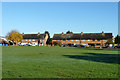
Elsinge Road, near Enfield
Houses on Elsinge Road, a residential road in north London's outer suburbs.
This image was taken on a February day, as the sun was setting.
Image: © Malc McDonald
Taken: 1 Feb 2020
0.06 miles
2
Kempe Road, near Enfield
Kempe Road is a residential road in the outer suburbs of north London.
Image: © Malc McDonald
Taken: 1 Feb 2020
0.06 miles
3
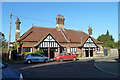
Ann Crowe's Almshouses, Almshouse Lane
These are older than they look. They were built in 1893, before the coming of the nearby railway. Ann Crowe's first almshouses were built prior to 1763, seemingly on another site, as part of the present site was donated to the charity by Henry Carrington Bowles in 1893.
Image: © Robin Webster
Taken: 11 Nov 2012
0.07 miles
4
Sunset at Yews Avenue, near Enfield
Yews Avenue, a residential cul-de-sac in the outer suburbs of north London.
This photograph was taken as the sun was setting on a February day.
Image: © Malc McDonald
Taken: 1 Feb 2020
0.07 miles
5

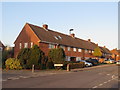
Elsinge Road, near Enfield
Elsinge Road in north London's outer suburbs.
This image was taken on a February day, as the sun was setting. Trees were bare for the winter season.
Image: © Malc McDonald
Taken: 1 Feb 2020
0.08 miles
6
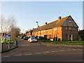
Houses on Yews Avenue
These are all the houses on the short close.
Image: © Robin Webster
Taken: 11 Nov 2012
0.10 miles
7
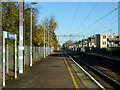
On Turkey Street station
Originally called Fortyhill, the name changed in 1960.
Image: © Robin Webster
Taken: 11 Nov 2012
0.11 miles
8
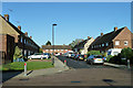
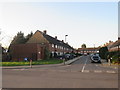
Kempe Road
It continues to the right at the far end.
Image: © Robin Webster
Taken: 11 Nov 2012
0.11 miles
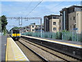
10
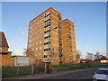
Brookbank, Turkey Street, near Enfield
A block of flats named Brookbank, on Turkey Street in the outer suburbs of north London.
Image: © Malc McDonald
Taken: 1 Feb 2020
0.12 miles