IMAGES TAKEN NEAR TO
Dendridge Close, ENFIELD, EN1 4PN
Introduction
This page details the photographs taken nearby to Dendridge Close, EN1 4PN by members of the Geograph project.
The Geograph project started in 2005 with the aim of publishing, organising and preserving representative images for every square kilometre of Great Britain, Ireland and the Isle of Man.

There are currently over 7.5m images from over14,400 individuals and you can help contribute to the project by visiting https://www.geograph.org.uk
Image Map (Loading...)


Getting Data...Please wait
Leaflet Map data © OpenStreetMap
Images are licensed for reuse under creativecommons.org/licenses/by-sa/2.0
Notes
- Clicking on the map will re-center to the selected point.
- The higher the marker number, the further away the image location is from the centre of the postcode.
Image Listing (107 Images Found)
Images are licensed for reuse under creativecommons.org/licenses/by-sa/2.0
Image
Details
Distance
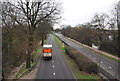
4
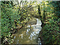
The Turkey Brook
From the A10 bridge.
Image: © Robin Webster
Taken: 11 Nov 2012
0.07 miles
7
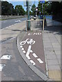
Very short cycle lane
With somewhat confusing markings and a mildly unnecessary message at the railings. Situated on the northeast corner of the junction of Turkey Street and the Great Cambridge Road (A10).
Image: © Mike Quinn
Taken: 30 Jul 2014
0.09 miles
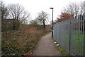
9
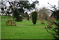
Garden of Remembrance, Enfield Crematorium
Image: © N Chadwick
Taken: 3 Feb 2013
0.09 miles
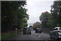
10
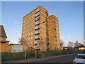
Brookbank, Turkey Street, near Enfield
A block of flats named Brookbank, on Turkey Street in the outer suburbs of north London.
Image: © Malc McDonald
Taken: 1 Feb 2020
0.10 miles