IMAGES TAKEN NEAR TO
Maltby Drive, ENFIELD, EN1 4ES
Introduction
This page details the photographs taken nearby to Maltby Drive, EN1 4ES by members of the Geograph project.
The Geograph project started in 2005 with the aim of publishing, organising and preserving representative images for every square kilometre of Great Britain, Ireland and the Isle of Man.

There are currently over 7.5m images from over14,400 individuals and you can help contribute to the project by visiting https://www.geograph.org.uk
Image Map (Loading...)


Getting Data...Please wait
Leaflet Map data © OpenStreetMap
Images are licensed for reuse under creativecommons.org/licenses/by-sa/2.0
Notes
- Clicking on the map will re-center to the selected point.
- The higher the marker number, the further away the image location is from the centre of the postcode.
Image Listing (10 Images Found)
Images are licensed for reuse under creativecommons.org/licenses/by-sa/2.0
Image
Details
Distance
1
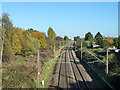
Railway north of Hoe Lane bridge
The Hackney Downs and Cheshunt (via Turkey Street) Line, with Turkey Street the next station in this direction.
Image: © Robin Webster
Taken: 11 Nov 2012
0.15 miles
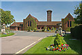
3

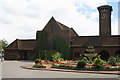
Enfield Crematorium, Great Cambridge Road, Enfield
Situated east of the A10 Great Cambridge Road. Can only be accessed when travelling south.
Image: © Christine Matthews
Taken: 15 Nov 2011
0.19 miles
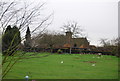
7
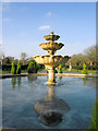
Fountain, Enfield Crematorium, Enfield
Situated close to the chapels.
Image: © Christine Matthews
Taken: 15 Nov 2011
0.19 miles
8

Fountain, Enfield Crematorium, Enfield
Looking west from close to the chapel entrance.
Image: © Christine Matthews
Taken: 15 Nov 2011
0.19 miles
9
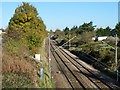
Railway north of Palmers Lane bridge
The Hackney Downs and Cheshunt (via Turkey Street) Line, with Turkey Street the next station in this direction.
Image: © Robin Webster
Taken: 11 Nov 2012
0.22 miles
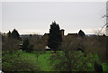
10
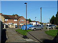
Stoneleigh Avenue
Viewed from the footway at the end of Palmers Lane.
Image: © Robin Webster
Taken: 11 Nov 2012
0.23 miles