IMAGES TAKEN NEAR TO
St. Andrews Road, ENFIELD, EN1 3UB
Introduction
This page details the photographs taken nearby to St. Andrews Road, EN1 3UB by members of the Geograph project.
The Geograph project started in 2005 with the aim of publishing, organising and preserving representative images for every square kilometre of Great Britain, Ireland and the Isle of Man.

There are currently over 7.5m images from over14,400 individuals and you can help contribute to the project by visiting https://www.geograph.org.uk
Image Map (Loading...)


Getting Data...Please wait
Leaflet Map data © OpenStreetMap
Images are licensed for reuse under creativecommons.org/licenses/by-sa/2.0
Notes
- Clicking on the map will re-center to the selected point.
- The higher the marker number, the further away the image location is from the centre of the postcode.
Image Listing (412 Images Found)
Images are licensed for reuse under creativecommons.org/licenses/by-sa/2.0
Image
Details
Distance
1
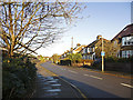
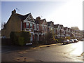
Fir Tree Walk, Enfield
Fir Tree Walk as seen from Churchbury Lane.
Image: © Christine Matthews
Taken: 17 Dec 2008
0.01 miles
2
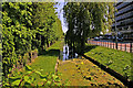
New River Loop, Southbury Road, Enfield
Looking east down the New River Loop Image] from where the watercourse goes underground.
Image: © Christine Matthews
Taken: 11 May 2008
0.01 miles
3
New River Loop, Southbury Road, Enfield
Where the New River Loop goes underground to emerge near the Civic Centre in Silver Street. Image]
Image: © Christine Matthews
Taken: 11 May 2008
0.01 miles
5
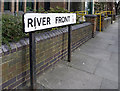
River Front sign, Enfield
River Front is parallel to Southbury Road. The New River Loop is between River Front and Southbury Road.
Image: © Christine Matthews
Taken: 23 Mar 2009
0.03 miles
6
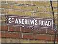
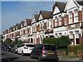
St Andrews Road, Enfield
St Andrews Road as seen from Churchbury Lane.
Image: © Christine Matthews
Taken: 17 Dec 2008
0.03 miles
7
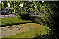
New River Loop, Southbury Road, Enfield
Looking west down the New River Loop towards Enfield Town from the bridge halfway along this section of water. Image]
Image: © Christine Matthews
Taken: 11 May 2008
0.03 miles
8
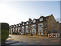
St Andrews Road, Enfield
St Andrews Road as seen from Churchbury Lane.
Image: © Christine Matthews
Taken: 17 Dec 2008
0.03 miles
9
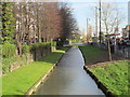
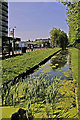
The New River by River Front, EN1
Neither new nor a river, but an aqueduct built in the early 17th C to supply London with water from Hertfordshire - see the Wiki entry http://en.wikipedia.org/wiki/New_River_(England) .
Image: © Mike Quinn
Taken: 5 Mar 2014
0.04 miles