IMAGES TAKEN NEAR TO
River Front, ENFIELD, EN1 3TF
Introduction
This page details the photographs taken nearby to River Front, EN1 3TF by members of the Geograph project.
The Geograph project started in 2005 with the aim of publishing, organising and preserving representative images for every square kilometre of Great Britain, Ireland and the Isle of Man.

There are currently over 7.5m images from over14,400 individuals and you can help contribute to the project by visiting https://www.geograph.org.uk
Image Map (Loading...)


Getting Data...Please wait
Leaflet Map data © OpenStreetMap
Images are licensed for reuse under creativecommons.org/licenses/by-sa/2.0
Notes
- Clicking on the map will re-center to the selected point.
- The higher the marker number, the further away the image location is from the centre of the postcode.
Image Listing (377 Images Found)
Images are licensed for reuse under creativecommons.org/licenses/by-sa/2.0
Image
Details
Distance
1
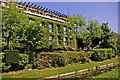
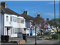
Nicholas House with New River Loop, Southbury Road, Enfield
Nicholas House overlooks the New River Loop and is more attractive than most office buildings.
Image: © Christine Matthews
Taken: 11 May 2008
0.01 miles
2
New River Loop, Southbury Road, Enfield
Looking east along the drained New River Loop. Compare to Image
Image: © Christine Matthews
Taken: 23 Mar 2009
0.01 miles
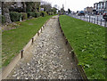
3
New River Loop, Southbury Road, Enfield
Looking east down the New River Loop towards Willow Road.Image]
Image: © Christine Matthews
Taken: 11 May 2008
0.01 miles
4
New River Loop, Southbury Road, Enfield
"Wot no Water!". The New River Loop has been drained for cleaning etc. and the warm, dry weather has dried up the mud. Image] is how it usually looks. In fact I went past it again the next day and it was being re-filled.
Image: © Christine Matthews
Taken: 23 Mar 2009
0.01 miles
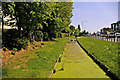
6

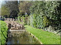
The New River in the centre of Enfield
The New River was completed between 1609 and its official opening on 29th September 1613. It was designed to bring clean water to London at a time when the heavily-polluted River Thames was the main source of drinking water. Sir Hugh Myddleton devised a 40 mile course that followed the contours of the land and only dropped about two inches every mile. It ran from springs near Ware in Hertfordshire to New River Head near the Angel, Islington but now finishes at Stoke Newington.
The New River remains an essential part of London’s water supply. The part to the south of Stoke Newington, where it survives, is more like a linear pond, but from Green Lanes upriver the water still flows as it has done for over 400 years. Much of it is followed by the New River Path but not here next to Southbury Road in the centre of Enfield where it is more an ornamental feature. This view looks upriver.
Image: © Marathon
Taken: 15 Mar 2017
0.02 miles
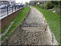
7
The New River in the centre of Enfield
The New River was completed between 1609 and its official opening on 29th September 1613. It was designed to bring clean water to London at a time when the heavily-polluted River Thames was the main source of drinking water. Sir Hugh Myddleton devised a 40 mile course that followed the contours of the land and only dropped about two inches every mile. It ran from springs near Ware in Hertfordshire to New River Head near the Angel, Islington but now finishes at Stoke Newington.
The New River remains an essential part of London’s water supply. The part to the south of Stoke Newington, where it survives, is more like a linear pond, but from Green Lanes upriver the water still flows as it has done for over 400 years. Much of it is followed by the New River Path but not here in the centre of Enfield where it is more an ornamental feature. This view is from the bridge carrying Willow Road and over it looks downriver with the busy Southbury Road on the left.
Image: © Marathon
Taken: 15 Mar 2017
0.02 miles
8
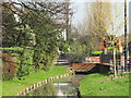
The New River by River Front, EN1
Photo taken from the footbridge shown in Image
Image: © Mike Quinn
Taken: 5 Mar 2014
0.02 miles
9
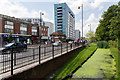
New River off Southbury Road
View west along Southbury Road with a section of the New River running alongside.
Image: © David P Howard
Taken: 24 Jul 2014
0.03 miles
10
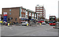
Southbury Road
Seen at the junction with Willow Road - on the right. The road on the left leads to the Tesco superstore. The parade of shops is one half of Savoy Parade - see Image for a photograph of the other half.
Image: © Martin Addison
Taken: 12 Feb 2011
0.03 miles