IMAGES TAKEN NEAR TO
Mafeking Road, ENFIELD, EN1 3SS
Introduction
This page details the photographs taken nearby to Mafeking Road, EN1 3SS by members of the Geograph project.
The Geograph project started in 2005 with the aim of publishing, organising and preserving representative images for every square kilometre of Great Britain, Ireland and the Isle of Man.

There are currently over 7.5m images from over14,400 individuals and you can help contribute to the project by visiting https://www.geograph.org.uk
Image Map (Loading...)


Getting Data...Please wait
Leaflet Map data © OpenStreetMap
Images are licensed for reuse under creativecommons.org/licenses/by-sa/2.0
Notes
- Clicking on the map will re-center to the selected point.
- The higher the marker number, the further away the image location is from the centre of the postcode.
Image Listing (78 Images Found)
Images are licensed for reuse under creativecommons.org/licenses/by-sa/2.0
Image
Details
Distance
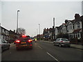
1
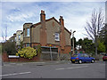
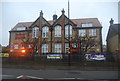
Mafeking Road, Enfield
Mafeking Road is a turning off the north side of Southbury Road.
Image: © Christine Matthews
Taken: 23 Mar 2009
0.03 miles
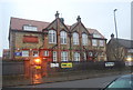
6
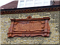
Original terracotta sign, George Spicer School, Enfield
Looking up at the wall of the George Spicer Primary School you can see this original terracotta sign for the "George Spicer Council School".
Image: © Christine Matthews
Taken: 23 Mar 2009
0.05 miles
7

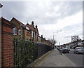
Shops, Southbury Road, Enfield
This small parade of shops is adjacent to the George Spicer Primary School, which can be seen to the left of the image beyond the shops. Regency Plaster Craft supplies traditional plasterwork for restoration work in houses and also apparently provides a fixing service.
Image: © Christine Matthews
Taken: 23 Mar 2009
0.05 miles
8
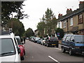
Southbury Road, Enfield (A110)
Looking along the Southbury Road towards the A10 (Great Cambridge Road), with the Geogre Spicer School on the left as seen from the north side of Southbury Road. The terracotta name on the school can be seen on the left Image
Image: © Christine Matthews
Taken: 23 Mar 2009
0.06 miles
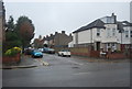
10
Southbury Road, Enfield Town
Approaching the town centre
Image: © David Howard
Taken: 12 Feb 2013
0.07 miles