IMAGES TAKEN NEAR TO
Central Avenue, ENFIELD, EN1 3QG
Introduction
This page details the photographs taken nearby to Central Avenue, EN1 3QG by members of the Geograph project.
The Geograph project started in 2005 with the aim of publishing, organising and preserving representative images for every square kilometre of Great Britain, Ireland and the Isle of Man.

There are currently over 7.5m images from over14,400 individuals and you can help contribute to the project by visiting https://www.geograph.org.uk
Image Map
Images are licensed for reuse under creativecommons.org/licenses/by-sa/2.0
Notes
- Clicking on the map will re-center to the selected point.
- The higher the marker number, the further away the image location is from the centre of the postcode.
Image Listing (16 Images Found)
Images are licensed for reuse under creativecommons.org/licenses/by-sa/2.0
Image
Details
Distance
1
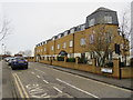
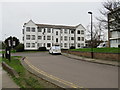
Autumn Close, near Enfield
Autumn Close is a residential road near Enfield, in the outer suburbs of north London.
Image: © Malc McDonald
Taken: 22 Feb 2020
0.06 miles
2
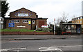
Suffolks Baptist Church
Located on Carterhatch Lane.
Image: © Martin Addison
Taken: 12 Feb 2011
0.07 miles
3
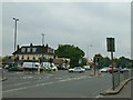
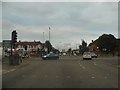
A10 junction and Halfway House
The Halfway House pub (now part of the Beefeater chain) and the junction of Carterhatch Lane with the A10 Great Cambridge Road.
Image: © Stephen Dawson
Taken: 16 May 2005
0.08 miles
4
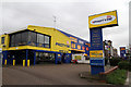
Protyre
One of many light industrial units along the A10 Great Cambridge Road in the Enfield area. Clearly this unit specialises in tyres. The adjacent unit is a self storage facility.
Image: © Martin Addison
Taken: 12 Feb 2011
0.10 miles
5
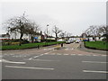
Carterhatch Lane at the junction of The Great Cambridge Road
Image: © David Howard
Taken: 23 Oct 2014
0.11 miles
6
The Approach, near Enfield
The Approach is a short road into a housing estate near Enfield, in the outer suburbs of north London.
Image: © Malc McDonald
Taken: 22 Feb 2020
0.12 miles
7
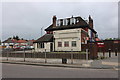
Toby Carvery on Carterhatch Lane, Enfield
On the corner of the A10
Image: © David Howard
Taken: 10 May 2020
0.12 miles
8
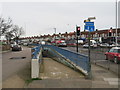
Pedestrian subway under the A10, near Enfield
A ramp leading down into a subway for pedestrians to cross beneath the trunk A10 road near Enfield, in the outer suburbs of north London.
Image: © Malc McDonald
Taken: 22 Feb 2020
0.12 miles
9
Great Cambridge Road slip road, near Enfield
A slip road for local traffic, running generally parallel to the trunk A10 road near Enfield in north London. Here, the slip road has turned away from the trunk road as it approaches a junction with Carterhatch Lane.
Image: © Malc McDonald
Taken: 22 Feb 2020
0.13 miles
10
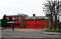
Enfield Fire Station
Located on Carterhatch Lane.
Image: © Martin Addison
Taken: 12 Feb 2011
0.15 miles