IMAGES TAKEN NEAR TO
Chailey Avenue, ENFIELD, EN1 3LZ
Introduction
This page details the photographs taken nearby to Chailey Avenue, EN1 3LZ by members of the Geograph project.
The Geograph project started in 2005 with the aim of publishing, organising and preserving representative images for every square kilometre of Great Britain, Ireland and the Isle of Man.

There are currently over 7.5m images from over14,400 individuals and you can help contribute to the project by visiting https://www.geograph.org.uk
Image Map (Loading...)


Getting Data...Please wait
Leaflet Map data © OpenStreetMap
Images are licensed for reuse under creativecommons.org/licenses/by-sa/2.0
Notes
- Clicking on the map will re-center to the selected point.
- The higher the marker number, the further away the image location is from the centre of the postcode.
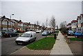
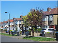
Image Listing (74 Images Found)
Images are licensed for reuse under creativecommons.org/licenses/by-sa/2.0
Image
Details
Distance
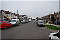
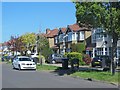
2
Tenniswood Rd
A suburban street in Enfield.
Image: © N Chadwick
Taken: 3 Feb 2013
0.05 miles
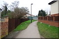
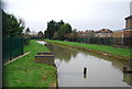
4

Path between Ladysmith Road and Tenniswood Road, EN1
The path crosses the New River - see Image
Image: © Mike Quinn
Taken: 4 May 2016
0.06 miles
7
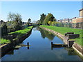
The New River south of Tenniswood Road, EN1
See Image
Image: © Mike Quinn
Taken: 4 May 2016
0.07 miles
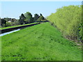
8
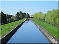
The New River in its embankment south of Carterhatch Lane (2)
See Image
Image: © Mike Quinn
Taken: 4 May 2016
0.08 miles
9
The New River in its embankment south of Carterhatch Lane
See Image
Image: © Mike Quinn
Taken: 4 May 2016
0.08 miles