IMAGES TAKEN NEAR TO
Pevensey Avenue, ENFIELD, EN1 3HU
Introduction
This page details the photographs taken nearby to Pevensey Avenue, EN1 3HU by members of the Geograph project.
The Geograph project started in 2005 with the aim of publishing, organising and preserving representative images for every square kilometre of Great Britain, Ireland and the Isle of Man.

There are currently over 7.5m images from over14,400 individuals and you can help contribute to the project by visiting https://www.geograph.org.uk
Image Map (Loading...)


Getting Data...Please wait
Leaflet Map data © OpenStreetMap
Images are licensed for reuse under creativecommons.org/licenses/by-sa/2.0
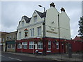
Notes
- Clicking on the map will re-center to the selected point.
- The higher the marker number, the further away the image location is from the centre of the postcode.
Image Listing (57 Images Found)
Images are licensed for reuse under creativecommons.org/licenses/by-sa/2.0
Image
Details
Distance
1
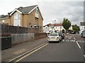
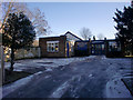
Churchbury Road at the junction of Churchbury Lane
Image: © David Howard
Taken: 21 Aug 2014
0.03 miles
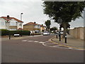
5
Emmanuel Centre, Baker Street, Enfield
Image: © Christine Matthews
Taken: 30 Jan 2010
0.10 miles
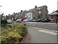
8
Aldersbrook Avenue at the junction of Churchbury Lane
Image: © David Howard
Taken: 21 Aug 2014
0.10 miles
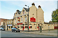
10
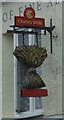
Sign for the Wheatsheaf, Enfield
See Image] for context.
Image: © JThomas
Taken: 27 Jul 2019
0.10 miles