IMAGES TAKEN NEAR TO
Tenniswood Road, ENFIELD, EN1 3HF
Introduction
This page details the photographs taken nearby to Tenniswood Road, EN1 3HF by members of the Geograph project.
The Geograph project started in 2005 with the aim of publishing, organising and preserving representative images for every square kilometre of Great Britain, Ireland and the Isle of Man.

There are currently over 7.5m images from over14,400 individuals and you can help contribute to the project by visiting https://www.geograph.org.uk
Image Map (37 Images)


Getting Data...Please wait
Leaflet Map data © OpenStreetMap
Images are licensed for reuse under creativecommons.org/licenses/by-sa/2.0
Notes
- Clicking on the map will re-center to the selected point.
- The higher the marker number, the further away the image location is from the centre of the postcode.
Image Listing (37 Images Found)
Images are licensed for reuse under creativecommons.org/licenses/by-sa/2.0
Image
Details
Distance

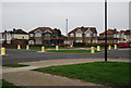
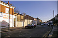
3
Willow Rd
A suburban road in the Forty Hill suburb of Enfield.
Image: © N Chadwick
Taken: 3 Feb 2013
0.09 miles

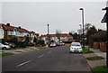
5
Eastbury Avenue
A suburban street in the forty Hill district of Enfield.
Image: © N Chadwick
Taken: 3 Feb 2013
0.12 miles
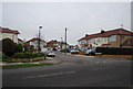
6
Carisbrooke Close
A suburban street in the forty Hill district of Enfield.
Image: © N Chadwick
Taken: 3 Feb 2013
0.13 miles


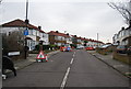
10
Canonbury Road, Enfield
Canonbury Road is off Baker Street and opposite the junction with Lancaster Road.
Image: © Christine Matthews
Taken: 6 Jan 2008
0.17 miles