IMAGES TAKEN NEAR TO
Willow Road, ENFIELD, EN1 3AT
Introduction
This page details the photographs taken nearby to Willow Road, EN1 3AT by members of the Geograph project.
The Geograph project started in 2005 with the aim of publishing, organising and preserving representative images for every square kilometre of Great Britain, Ireland and the Isle of Man.

There are currently over 7.5m images from over14,400 individuals and you can help contribute to the project by visiting https://www.geograph.org.uk
Image Map (Loading...)


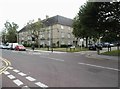
Getting Data...Please wait
Leaflet Map data © OpenStreetMap
Images are licensed for reuse under creativecommons.org/licenses/by-sa/2.0
Notes
- Clicking on the map will re-center to the selected point.
- The higher the marker number, the further away the image location is from the centre of the postcode.
Image Listing (67 Images Found)
Images are licensed for reuse under creativecommons.org/licenses/by-sa/2.0
Image
Details
Distance
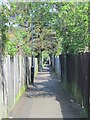
1

Footpath between Churchbury Close and Willow Road, EN1
Image: © Mike Quinn
Taken: 4 May 2016
0.03 miles

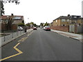
4

Churchbury Lane north of Churchbury Close, EN1
Image: © Mike Quinn
Taken: 4 May 2016
0.09 miles
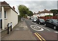
6
Footpath between Willow Road and Connaught Avenue, EN1
Image: © Mike Quinn
Taken: 4 May 2016
0.10 miles
7
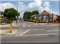
Churchbury Lane
View across Parsonage Lane at the junction with Churchbury Lane.
Note the 20 mph speed limit signs for a residential street.
Image: © David P Howard
Taken: 24 Jul 2014
0.10 miles
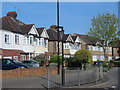
8
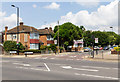
Churchbury Lane
View NNW across Parsonage Lane at the junction with Churchbury Lane.
Note the 20 mph speed limit signs for a residential street.
Image: © David P Howard
Taken: 24 Jul 2014
0.10 miles