IMAGES TAKEN NEAR TO
Genotin Road, ENFIELD, EN1 2AG
Introduction
This page details the photographs taken nearby to Genotin Road, EN1 2AG by members of the Geograph project.
The Geograph project started in 2005 with the aim of publishing, organising and preserving representative images for every square kilometre of Great Britain, Ireland and the Isle of Man.

There are currently over 7.5m images from over14,400 individuals and you can help contribute to the project by visiting https://www.geograph.org.uk
Image Map (Loading...)


Getting Data...Please wait
Leaflet Map data © OpenStreetMap
Images are licensed for reuse under creativecommons.org/licenses/by-sa/2.0
Notes
- Clicking on the map will re-center to the selected point.
- The higher the marker number, the further away the image location is from the centre of the postcode.
Image Listing (359 Images Found)
Images are licensed for reuse under creativecommons.org/licenses/by-sa/2.0
Image
Details
Distance
1
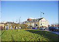
Genotin Road, Enfield
Looking across Genotin Road towards the new housing development.
Image: © Christine Matthews
Taken: 7 Dec 2008
0.04 miles
2
Genotin Road, Enfield
Looking south down Genotin Road towards Genotin Terrace, which can be seen on the right, a gem from the past in the centre of Enfield.
Image: © Christine Matthews
Taken: 7 Dec 2008
0.04 miles
3
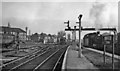
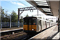
Enfield Town station: platform end scene towards London
View SE, towards Liverpool Street via Seven Sisters and Hackney Downs: terminus of intensive suburban service, not electrified until 11/60. Two of the Hill/Gresley N7 class 0-6-2Ts normally employed are seen: Nos. 69660 (built 11/25 as No. 941, withdrawn 5/59) on the right and No. 69671 (built 1/26 as No. 988, withdrawn 9/62) further back.
Image: © Ben Brooksbank
Taken: 14 Dec 1957
0.04 miles
4
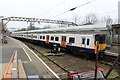
Enfield Town railway station
Opened as "Enfield" in 1849 by the Eastern Counties Railway, later part of the Great Eastern Railway, as the terminus of its line from London Bishopsgate (and later Liverpool Street). Trains originally ran via Edmonton (later called Angel Road). A slightly shorter line was opened in 1872 via White Hart Lane, which is the route trains take today. "Town" was added to the name in 1886.
View north west towards the buffers.
Image: © Nigel Thompson
Taken: 30 May 2012
0.04 miles
5
Enfield Town station, 1991
View SE to the buffer-stops. See also Image
Image: © Ben Brooksbank
Taken: 4 Aug 1991
0.04 miles
6
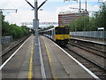
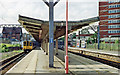
Overground train at Enfield Town
This is a terminal station.
Image: © Dr Neil Clifton
Taken: 23 Mar 2016
0.05 miles
7
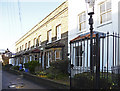
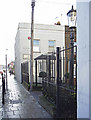
Genotin Terrace, Enfield
North side of Genotin Terrace as seen from Genotin Road.
Image: © Christine Matthews
Taken: 7 Dec 2008
0.05 miles
9
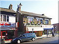
London Road, Enfield
Shops in London Road. This pair near the junction with Genotin Road show their origins as a pair of semi-detached houses. The Florida Cinema, later the Townhouse Nightclub, used to be on the site of the road junction and was demolished when the new road system and buildings in the town centre were completed a few years ago.
Image: © Christine Matthews
Taken: 7 Dec 2008
0.05 miles
10
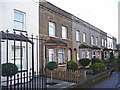
Genotin Terrace, Enfield
South side of Genotin Terrace, as seen from the corner of Genotin Road.
Image: © Christine Matthews
Taken: 7 Dec 2008
0.05 miles