IMAGES TAKEN NEAR TO
Crown Road, ENFIELD, EN1 1TH
Introduction
This page details the photographs taken nearby to Crown Road, EN1 1TH by members of the Geograph project.
The Geograph project started in 2005 with the aim of publishing, organising and preserving representative images for every square kilometre of Great Britain, Ireland and the Isle of Man.

There are currently over 7.5m images from over14,400 individuals and you can help contribute to the project by visiting https://www.geograph.org.uk
Image Map
Images are licensed for reuse under creativecommons.org/licenses/by-sa/2.0
Notes
- Clicking on the map will re-center to the selected point.
- The higher the marker number, the further away the image location is from the centre of the postcode.
Image Listing (14 Images Found)
Images are licensed for reuse under creativecommons.org/licenses/by-sa/2.0
Image
Details
Distance
1
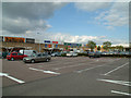
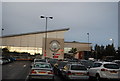
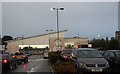
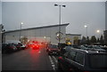
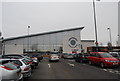
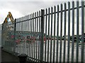
Retail park
Much of this square is retail park and supermarket.
Image: © Stephen Dawson
Taken: 11 May 2005
0.07 miles
2
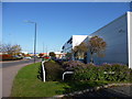
Baird Road, Enfield Trading Estate, Enfield
Baird Road leads to the trading estate. The Renault dealership is on the right.
Image: © Christine Matthews
Taken: 23 Oct 2009
0.17 miles
4
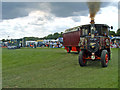
Enfield Playing Fields, Enfield
Enfield Playing Fields are used at the end of May every year to hold the Pageant of Motoring organised by the Whitewebbs Motor Museum. Here we see one of the Foden Steam Engines.
Image: © Christine Matthews
Taken: 31 May 2004
0.22 miles