IMAGES TAKEN NEAR TO
High Street, HODDESDON, EN11 8BL
Introduction
This page details the photographs taken nearby to High Street, EN11 8BL by members of the Geograph project.
The Geograph project started in 2005 with the aim of publishing, organising and preserving representative images for every square kilometre of Great Britain, Ireland and the Isle of Man.

There are currently over 7.5m images from over14,400 individuals and you can help contribute to the project by visiting https://www.geograph.org.uk
Image Map (Loading...)


Getting Data...Please wait
Leaflet Map data © OpenStreetMap
Images are licensed for reuse under creativecommons.org/licenses/by-sa/2.0
Notes
- Clicking on the map will re-center to the selected point.
- The higher the marker number, the further away the image location is from the centre of the postcode.
Image Listing (50 Images Found)
Images are licensed for reuse under creativecommons.org/licenses/by-sa/2.0
Image
Details
Distance
2
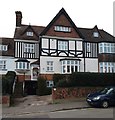
House on St Catharine's Road
One of the original houses on the St Catharine's estate, designed by the young Reginald Blomfield from 1883.
Image: © Chris Brown
Taken: 31 Jan 2019
0.03 miles
3

St Catharine's Road
One of the best sequences of picturesque streetscape on the St Catharine's estate.
Image: © Chris Brown
Taken: 31 Jan 2019
0.04 miles
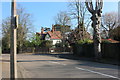
4

Spital Brook, Hoddesdon
The sign on the road shows it divides Hoddesdon and Broxbourne
Image: © David Howard
Taken: 20 Apr 2019
0.05 miles
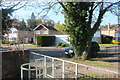
7
Bridge over Spitalbrook, St Catharine's estate
The position of this highly individual estate on the left bank of the Spitalbrook puts it in Hoddesdon, although it connects more naturally with other estates in Broxbourne and is part of the Broxbourne Conservation Area. The pierced bridge parapets, treating the stream crossing as something worthy of more than routine attention, establish the estate as something of a place apart immediately on entry from the Old North Road. Developed from 1883 onwards, the houses were designed by the architect Reginald Blomfield, most of whose early commissions were in the Hertford area.
Reginald Blomfield was later to have a huge influence on British landscape as the designer of both a much-copied template for a World War One memorial and the standard National Grid electricity distribution pylon. He also designed the rebuilding of the southern curve of Regent Street and Piccadilly Circus in London and of The Headrow and Eastgate in Leeds.
Image: © Chris Brown
Taken: 31 Jan 2019
0.06 miles
8

House access over Spitalbrook
Typical of the original sylvan suburban conception of the St Catharine's estate in the 1880s is this bridge connecting a house on the right bank of Spitalbrook (Broxbourne) with St Catharine's Road on the left bank (Hoddesdon).
Image: © Chris Brown
Taken: 31 Jan 2019
0.06 miles
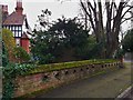
9
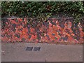
Garden wall, St Catharine's Road
"Crazy" brickwork and flint topping are typical of the attention to picturesque detail on the St Catharine's estate.
Image: © Chris Brown
Taken: 31 Jan 2019
0.07 miles
10
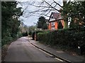
Osborne Road
The southern boundary of the St Catharine's estate is the Spitalbrook, behind the hedge on the left.
Image: © Chris Brown
Taken: 31 Jan 2019
0.09 miles