IMAGES TAKEN NEAR TO
Waterside Industrial Estate, Charlton Mead Lane, HODDESDON, EN11 0QR
Introduction
This page details the photographs taken nearby to Waterside Industrial Estate, Charlton Mead Lane, EN11 0QR by members of the Geograph project.
The Geograph project started in 2005 with the aim of publishing, organising and preserving representative images for every square kilometre of Great Britain, Ireland and the Isle of Man.

There are currently over 7.5m images from over14,400 individuals and you can help contribute to the project by visiting https://www.geograph.org.uk
Image Map
Images are licensed for reuse under creativecommons.org/licenses/by-sa/2.0
Notes
- Clicking on the map will re-center to the selected point.
- The higher the marker number, the further away the image location is from the centre of the postcode.
Image Listing (76 Images Found)
Images are licensed for reuse under creativecommons.org/licenses/by-sa/2.0
Image
Details
Distance
4

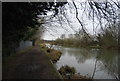
Fish and Eals, Dobbs Weir
Seen during an evening walk.
Image: © Christine Matthews
Taken: 7 Jul 2020
0.12 miles
5
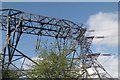
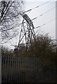
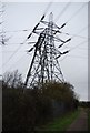
Rye House Pylons
Quite a tangle of wires around the Rye House power plant, beside the Lee Navigation.
Image: © Glyn Baker
Taken: 23 Apr 2016
0.13 miles
6
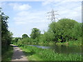
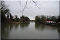
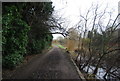
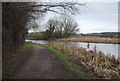
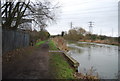
River Lea near Hoddesdon
Here, the River Lea (or Lee) forms the border between the counties of Hertfordshire (on this bank) and Essex (on the opposite bank).
The towpath is a shared path for cycling and walking.
Image: © Malc McDonald
Taken: 1 Jun 2013
0.13 miles