IMAGES TAKEN NEAR TO
Broxbourne Common, BROXBOURNE, EN10 7QS
Introduction
This page details the photographs taken nearby to Broxbourne Common, EN10 7QS by members of the Geograph project.
The Geograph project started in 2005 with the aim of publishing, organising and preserving representative images for every square kilometre of Great Britain, Ireland and the Isle of Man.

There are currently over 7.5m images from over14,400 individuals and you can help contribute to the project by visiting https://www.geograph.org.uk
Image Map
Images are licensed for reuse under creativecommons.org/licenses/by-sa/2.0
Notes
- Clicking on the map will re-center to the selected point.
- The higher the marker number, the further away the image location is from the centre of the postcode.
Image Listing (11 Images Found)
Images are licensed for reuse under creativecommons.org/licenses/by-sa/2.0
Image
Details
Distance
1
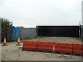
Abandoned entrance to Edgewood Farm
The old walls and gate (which were in good condition) have been removed and replaced with this fencing and clearly abandoned as now blocked from use. The edge of the roof on the right is a new building.
Image: © David Howard
Taken: 15 Oct 2015
0.02 miles
2
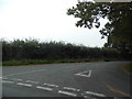
Pembridge Lane at the junction of Cock Lane
Image: © David Howard
Taken: 15 Oct 2015
0.08 miles
3

Pembridge Lane at the junction of Cock Lane
Image: © David Howard
Taken: 2 Dec 2017
0.08 miles
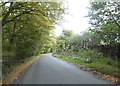
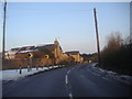
4
Ermine Street at Pembridge Lane
Ermine Street goes off as a Byway to the left in the trees at the junction with Cock Lane and Pembridge Lane (right)
Image: © Talisman
Taken: 3 May 2008
0.08 miles
6
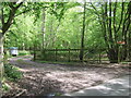
Entrance to Danemead Scout Camp
Looking from Cock Lane to the entrance to Danemead Scout Camp
Image: © Talisman
Taken: 3 May 2008
0.09 miles
7
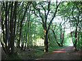
Ermine Street through Great Grove
A short section of bridleway but part of a much longer ancient route.
Image: © Stephen Craven
Taken: 4 Jun 2011
0.12 miles
8
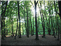
Great Grove
Deciduous woodland, that looks to have been coppiced in the past. Looking into the evening sun.
Image: © Stephen Craven
Taken: 4 Jun 2011
0.12 miles
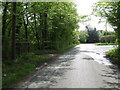
9
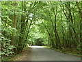
Pembridge Lane
Broad Riding Wood to the left, Lower White Stubbs to the right.
Image: © Robin Webster
Taken: 21 Aug 2015
0.19 miles
10
White Stubbs Lane, Broxbourne
The Highfield Veterinary Surgery is on the left.
Image: © David Howard
Taken: 7 Feb 2012
0.22 miles