IMAGES TAKEN NEAR TO
Nazeing New Road, BROXBOURNE, EN10 6SY
Introduction
This page details the photographs taken nearby to Nazeing New Road, EN10 6SY by members of the Geograph project.
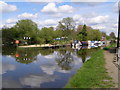
The Geograph project started in 2005 with the aim of publishing, organising and preserving representative images for every square kilometre of Great Britain, Ireland and the Isle of Man.

There are currently over 7.5m images from over14,400 individuals and you can help contribute to the project by visiting https://www.geograph.org.uk
Image Map (Loading...)


Getting Data...Please wait
Leaflet Map data © OpenStreetMap
Images are licensed for reuse under creativecommons.org/licenses/by-sa/2.0
Notes
- Clicking on the map will re-center to the selected point.
- The higher the marker number, the further away the image location is from the centre of the postcode.
Image Listing (51 Images Found)
Images are licensed for reuse under creativecommons.org/licenses/by-sa/2.0
Image
Details
Distance
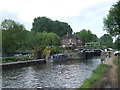
2
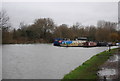
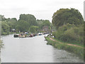
River Lea Navigation
Part of the Lea Valley Park. The river lea has been straightened in this section to allow barge traffic
Image: © Chris Hunt
Taken: 29 Apr 2006
0.07 miles
4
River Lee Navigation, Hoddesdon, Hertfordshire
Looking towards Broxbourne as seen from the bridge over the lock.
Image: © Christine Matthews
Taken: 1 Jul 2011
0.09 miles
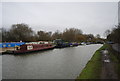
5
Lea Navigation at Nazeing
Image: © Stephen Craven
Taken: 15 Aug 2009
0.09 miles
7

River Lee Navigation, Hoddesdon, Hertfordshire
As seen from the lock.
Image: © Christine Matthews
Taken: 1 Jul 2011
0.09 miles
8
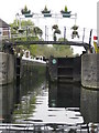
Carthagena Lock on River Lea
Entering the lock from the south
Image: © Ken Ripper
Taken: 20 Oct 2009
0.09 miles
9
Downstream from Cartheagena Lock
A much nicer cloudscape than a little earlier at Image
Image: © Glyn Baker
Taken: 23 Apr 2016
0.10 miles
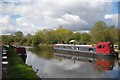
10
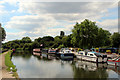
River Lee Navigation near Broxbourne
The waterway forms the border between the counties of Essex (on this bank) and Hertfordshire (on the opposite bank).
The towpath is a shared path for cycling and walking.
Image: © Malc McDonald
Taken: 1 Jun 2013
0.10 miles