IMAGES TAKEN NEAR TO
Slipe Lane, BROXBOURNE, EN10 6EX
Introduction
This page details the photographs taken nearby to Slipe Lane, EN10 6EX by members of the Geograph project.
The Geograph project started in 2005 with the aim of publishing, organising and preserving representative images for every square kilometre of Great Britain, Ireland and the Isle of Man.

There are currently over 7.5m images from over14,400 individuals and you can help contribute to the project by visiting https://www.geograph.org.uk
Image Map (Loading...)


Getting Data...Please wait
Leaflet Map data © OpenStreetMap
Images are licensed for reuse under creativecommons.org/licenses/by-sa/2.0
Notes
- Clicking on the map will re-center to the selected point.
- The higher the marker number, the further away the image location is from the centre of the postcode.
Image Listing (61 Images Found)
Images are licensed for reuse under creativecommons.org/licenses/by-sa/2.0
Image
Details
Distance
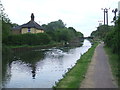
1
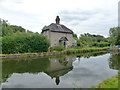
Cottage by Lee Navigation
This appears to be called King's Weir, taking its name from the weir just upstream to the left where the flowing river leaves the navigation and passes behind the cottage.
Image: © Robin Webster
Taken: 4 Sep 2015
0.00 miles
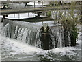
4
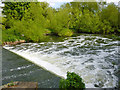
Below King's Weir
Visible is the simple second stage of the weir. The view is from River Lee Navigation bridge 49a, an unnavigable footbridge which crosses between the two stages of the weir. The upper stage has a convoluted crest of greater fall.
Image: © Robin Webster
Taken: 15 May 2016
0.02 miles
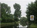
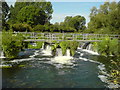
5
River Lea near Wormley
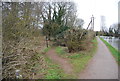
Here, the River Lea (or Lee) forms the border between the counties of Essex (on the opposite bank) and Hertfordshire (this bank). The towpath is a shared path for walking and cycling.
Image: © Malc McDonald
Taken: 1 Jun 2013
0.02 miles
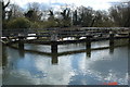
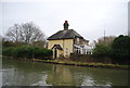
10
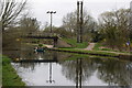
River Lee Navigation at King's Weir
The canal and footbridge looking south.
Image: © Trevor Harris
Taken: 27 Mar 2022
0.04 miles