
IMAGES TAKEN NEAR TO
Pitt Street, EDINBURGH, EH6 4BZ
Introduction
This page details the photographs taken nearby to Pitt Street, EH6 4BZ by members of the Geograph project.
The Geograph project started in 2005 with the aim of publishing, organising and preserving representative images for every square kilometre of Great Britain, Ireland and the Isle of Man.

There are currently over 7.5m images from over14,400 individuals and you can help contribute to the project by visiting https://www.geograph.org.uk
Image Map
Images are licensed for reuse under creativecommons.org/licenses/by-sa/2.0
Notes
- Clicking on the map will re-center to the selected point.
- The higher the marker number, the further away the image location is from the centre of the postcode.
Image Listing (239 Images Found)
Images are licensed for reuse under creativecommons.org/licenses/by-sa/2.0
Image
Details
Distance
1
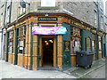
Lord Nelson, off Ferry Road
Positioned on the corner of Trafalgar Street and Trafalgar Lane - where else? Given the innate anti-English predisposition of many Scots, its presence indicates proximity to the port of Leith where, it may be presumed, some sailors were press-ganged into service on Nelson's ships. The muster book of H.M.S. Victory records 64 Scots aboard before the Battle of Trafalgar and there must have been more on board other ships of the fleet.
Image: © kim traynor
Taken: 7 Oct 2011
0.02 miles
2
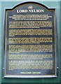
A potted history of Nelson, Trafalgar Lane
Providing this information is certainly a generous way of helping customers identify with their 'local', but to take it all in you'd have to read it on the way into the pub, while still sober.
Click the More sizes button for a larger, more easily read image.
Image: © kim traynor
Taken: 7 Oct 2011
0.02 miles

4
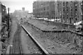
Bonnington (Edinburgh) Station (remains)
View ENE, towards North Leith; ex-NBR Edinburgh Waverley - Easter Road - North Leith branch, closed to passengers 16/6/47, goods ?7/68. (Very salubrious!)
Image: © Ben Brooksbank
Taken: 19 Sep 1962
0.02 miles

6

Rails to trails, Leith
Former railway serving the docks.
Image: © Richard Webb
Taken: 15 Apr 2021
0.04 miles
7

Bonnington Station, 48 years on
An attempt to produce a photo for comparison with that of Ben Brookbank Image taken in 1962. Not much is visible through the trees that have grown since the trains stopped running, and the prominent tenement in Ben's photo has disappeared completely, to be replaced by a modern version. The railway is now a foot and cycle path, one of many on the dead railways of Edinburgh. This was taken from the bridge over the railway [Newhaven Road], which I think may have been Ben's viewpoint. A more distant view from the track bed is Image
Image: © M J Richardson
Taken: 15 May 2010
0.04 miles
8

Bonnington Station, 2010
Taken for comparison with Ben Brookbank's view from 1962 Image The remains of the platform are still visible, as are the retaining walls, but the stone tenement building in the earlier photo [and the washing on the lines] has gone, to be replaced by a modern tenement. See also Image
Image: © M J Richardson
Taken: 15 May 2010
0.04 miles
9

Former Railway Platform
Beside the path and cycle route are the remains of the platform associated with the station beside Newhaven Road, which crosses the former railway on the bridge in the distance.
Image: © Anne Burgess
Taken: 5 Mar 2020
0.05 miles
10

Edinburgh, Leith and Granton Railway
One of the Leith Docks railways, now a shared use path.
Image: © Richard Webb
Taken: 15 Apr 2021
0.05 miles