
IMAGES TAKEN NEAR TO
Rannoch Place, EDINBURGH, EH4 7HH
Introduction
This page details the photographs taken nearby to Rannoch Place, EH4 7HH by members of the Geograph project.
The Geograph project started in 2005 with the aim of publishing, organising and preserving representative images for every square kilometre of Great Britain, Ireland and the Isle of Man.

There are currently over 7.5m images from over14,400 individuals and you can help contribute to the project by visiting https://www.geograph.org.uk
Image Map
Images are licensed for reuse under creativecommons.org/licenses/by-sa/2.0
Notes
- Clicking on the map will re-center to the selected point.
- The higher the marker number, the further away the image location is from the centre of the postcode.
Image Listing (23 Images Found)
Images are licensed for reuse under creativecommons.org/licenses/by-sa/2.0
Image
Details
Distance
1

Drum Brae Drive looking towards Corstorphine Hill
Image: © M J Richardson
Taken: 22 Aug 2008
0.09 miles
2

Oak Lane
Number 5 to 7 Oak Lane are Category C Listed. The house was part of the farm buildings at Clermiston Mains Farm. It dates from the 18th century, but the ogeen stair tower is a later addition, possibly by Sir Robert Lorimer. See http://portal.historicenvironment.scot/designation/LB44753 for more informstion.
Image: © Anne Burgess
Taken: 26 Sep 2021
0.10 miles
3

1 Oak Lane
This is said to be a house and workshop designed by Hamish Haswell-Smith.
Image: © Anne Burgess
Taken: 26 Sep 2021
0.11 miles
4
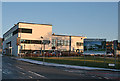
Drum Brae Community Centre
The sign on poles in the grass says that the centre, due to open in early 2012, contains the library. local council services, police, day care and facilities for adult with learning difficulties. Confusingly, a second sign points along Rannoch road to Rannoch Community Centre, which I think is its old name. It has made it on to the current online maps.
Image: © Anne Burgess
Taken: 5 Dec 2012
0.15 miles
5

St Andrew's Church
The church was designed in 1954-1958 by Basil Spence and Partners. It and its associated buildings are Category C Listed. This is the south elevation of the church. See http://portal.historicenvironment.scot/designation/LB47716 for more information.
Image: © Anne Burgess
Taken: 26 Sep 2021
0.16 miles
6

St Andrew's Church
The church was designed in 1954-1958 by Basil Spence and Partners. It and its associated buildings are Category C Listed. This is the gable of the church. See http://portal.historicenvironment.scot/designation/LB47716 for more information.
Image: © Anne Burgess
Taken: 26 Sep 2021
0.16 miles
7

St Andrew's Church and Belfry
The church was designed in 1954-1958 by Basil Spence and Partners. It and its associated buildings are Category C Listed. This is the gable of the church on the left, with the belfry to the right. See https://www.trove.scot/place/149785 for more information.
Image: © Anne Burgess
Taken: 26 Sep 2021
0.16 miles
8

St Andrew's Church
The church was designed in 1954-1958 by Basil Spence and Partners. It and its associated buildings are Category C Listed. This is the gable of the church on the right, with the church hall to the left. See http://portal.historicenvironment.scot/designation/LB47716 for more information.
Image: © Anne Burgess
Taken: 26 Sep 2021
0.16 miles
9

Clermiston Medway
Looking down from St Andrew's Church.
Image: © Anne Burgess
Taken: 26 Sep 2021
0.17 miles
10

Clermiston Road North
Looking north from outside the Best Western Hotel near the junction with Drum Brae Drive.
Image: © michael ely
Taken: 12 Apr 2011
0.17 miles