IMAGES TAKEN NEAR TO
Harvest Wynd, NEWBRIDGE, EH28 8QL
Introduction
This page details the photographs taken nearby to Harvest Wynd, EH28 8QL by members of the Geograph project.
The Geograph project started in 2005 with the aim of publishing, organising and preserving representative images for every square kilometre of Great Britain, Ireland and the Isle of Man.

There are currently over 7.5m images from over14,400 individuals and you can help contribute to the project by visiting https://www.geograph.org.uk
Image Map
Images are licensed for reuse under creativecommons.org/licenses/by-sa/2.0
Notes
- Clicking on the map will re-center to the selected point.
- The higher the marker number, the further away the image location is from the centre of the postcode.
Image Listing (44 Images Found)
Images are licensed for reuse under creativecommons.org/licenses/by-sa/2.0
Image
Details
Distance
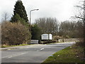
1
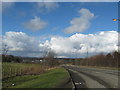
Nearly at Ratho Station
The minor road passing the grounds of the Norton House Hotel.
Image: © James Denham
Taken: 1 Mar 2009
0.04 miles
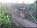
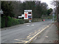
3
Station Road, Ratho Station
The bridge in the foreground crosses the disused and overgrown South Queensferry Branch of the Edinburgh and Glasgow Railway. The present Glasgow to Edinburgh main line is in the distance.
Image: © Thomas Nugent
Taken: 3 Mar 2013
0.06 miles
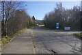
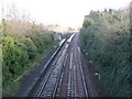
4
Station Road
The Glasgow to Edinburgh main line is to the left, but the station closed in 1951.
Image: © Thomas Nugent
Taken: 3 Mar 2013
0.06 miles
5
Old bridge at Ratho Station
The bridge that carried the Ratho to Ratho Bridge road over the railway. Now disused as a road and road bridge, but still used as a footbridge. Thanks to Simon Sweeney, who wrote to say that, once closed to traffic, this old road was known as the 'curly wurly' or 'bendy wendy' to the young local skate boarders who used the bridge and winding road on the hill.
Image: © M J Richardson
Taken: 26 Nov 2008
0.07 miles
7
The line to Edinburgh at Ratho Station
The name of the place, but no station there now.
Image: © M J Richardson
Taken: 26 Nov 2008
0.08 miles
8
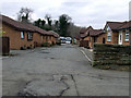
Station Road
Houses on the trackbed of the disused South Queensferry Branch of the Edinburgh and Glasgow Railway.
Image: © Thomas Nugent
Taken: 3 Mar 2013
0.09 miles
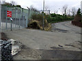
9
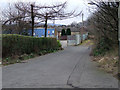
Industrial Area of Station Road
Near the bridge over the former South Queensferry Branch of the Edinburgh and Glasgow Railway.
Image: © Thomas Nugent
Taken: 3 Mar 2013
0.09 miles
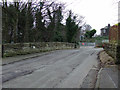
10
Station Road, Ratho Station
Looking towards the railway line. Despite the name of the road and of the village, there is no station here (closed 1951).
Image: © Thomas Nugent
Taken: 3 Mar 2013
0.09 miles