
IMAGES TAKEN NEAR TO
Ladywell Road, EDINBURGH, EH12 7TF
Introduction
This page details the photographs taken nearby to Ladywell Road, EH12 7TF by members of the Geograph project.
The Geograph project started in 2005 with the aim of publishing, organising and preserving representative images for every square kilometre of Great Britain, Ireland and the Isle of Man.

There are currently over 7.5m images from over14,400 individuals and you can help contribute to the project by visiting https://www.geograph.org.uk
Image Map
Images are licensed for reuse under creativecommons.org/licenses/by-sa/2.0
Notes
- Clicking on the map will re-center to the selected point.
- The higher the marker number, the further away the image location is from the centre of the postcode.
Image Listing (60 Images Found)
Images are licensed for reuse under creativecommons.org/licenses/by-sa/2.0
Image
Details
Distance
1
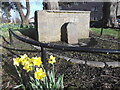
Old milestone
Another view of the Post Horse Duty stone in Corstorphine. It was once on the main road to Glasgow but removed sometime after 1850 and used as a garden ornament in Dunsmuir House. When the house was demolished it was set up on the grassy area nearby. These stones are unique to Edinburgh and were set in a 5 mile radius from the original GPO at 16-20 Waterloo Place. Eight are still in situ.
Image: © Chris Minto
Taken: 21 Mar 2017
0.03 miles
2
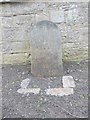
Old Milestone by Dunsmuir Court, Corstorphine, Edinburgh
GPO cab horse stone by the UC road, in parish of Corstorphine (City of Edinburgh District), Dunsmuir Court, off Ladywell Road, set against free-standing wall on grassed area, opposite Murray Cottages.
Inscription is unclear but stone is dated 1824.
Surveyed
Milestone Society National ID: CE_EDGW05P
Image: © Milestone Society
Taken: Unknown
0.04 miles
3
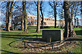
Ladywell House and a Stone
Despite my best endeavours I was unable to decipher the inscription on the central stone against the wall inside the railing. I could read the word 'Edinburgh' and 'payable' but not much more. I hope someone has recorded it before it is lost forever. The building, Ladywell House accommodates part of the General Register Office for Scotland, dealing with census and population statistics.
Image: © Anne Burgess
Taken: 14 Feb 2013
0.05 miles
4

Leaving old Corstorphine behind
After enjoying the old village, a strip of modern flats awaits on the way to South Gyle.
Image: © James Denham
Taken: 10 Oct 2010
0.08 miles
6
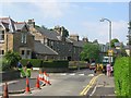
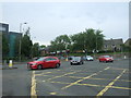
Building speed humps, Corstorphine.
Edinburgh is home to a lot of speed humps, and they are multiplying. While proven effective in lowering speeds in residential areas, they are a pain when out on the bike. Some studies suggest that road humps are the only effective way of enforcing a 20mph/30kph speed limit. Residential area just off the busy main shopping street of Corstorphine.
Image: © Richard Webb
Taken: 8 Jun 2005
0.11 miles
7
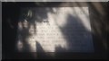
The Physic Well of Corstorphine
"The Physic Well.
"Much Prized in the eighteenth century for its medicinal water. This well was on the southside of the Stank Burn & some 40 yards east of this spot where its well head was rebuilt in 1972 when the burn was culverted."
This is one of Corstorphine's two lost wells, the other being the Lady Well, which gives its name to some of the streets nearby. The two are frequently confused. Corstorphine may in fact derive its name from these wells - see the book "Literary Corstorphine".
This site is at the back of Dunsmuir Court, and is well hidden. Dunsmuir Court is social housing, but there used to be a mansion house near here. The well is not signposted from the main road.
"Stank" is an old Scots word for a ditch (Gaelic: staing), and was applied to the burn which formerly flowed across here, and connected the Gogar Loch to Corstorphine Loch.
Image: © Raymond Bell
Taken: 24 Aug 2018
0.12 miles
8

Approaching Drumbrae roundabout
This is where the A8 and the B701 meet. We are looking north on Meadow Place Road (B701). The roundabout is 150 metres to the north.
Image: © michael ely
Taken: 22 Feb 2011
0.14 miles
9
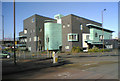
Corstorphine Police Station
Maybe it's supposed to look horrible and imposing. Good grief, they've done a good job. The whole lot looks a little hastily constructed. The materials don't look like they are all from the same batch. The green facings appear to be rusting in parts. Heck, it's only been up a couple of years. Not a pretty building at all but I dare say it wasn't designed with a prize in mind. Aerial - http://maps.google.co.uk/?t=h&ll=55.93965,-3.2935&spn=0.002788,0.007124&t=h
Image: © Simon Johnston
Taken: 2 Mar 2006
0.14 miles
