
IMAGES TAKEN NEAR TO
Swanston Row, EDINBURGH, EH10 7EJ
Introduction
This page details the photographs taken nearby to Swanston Row, EH10 7EJ by members of the Geograph project.
The Geograph project started in 2005 with the aim of publishing, organising and preserving representative images for every square kilometre of Great Britain, Ireland and the Isle of Man.

There are currently over 7.5m images from over14,400 individuals and you can help contribute to the project by visiting https://www.geograph.org.uk
Image Map
Images are licensed for reuse under creativecommons.org/licenses/by-sa/2.0
Notes
- Clicking on the map will re-center to the selected point.
- The higher the marker number, the further away the image location is from the centre of the postcode.
Image Listing (28 Images Found)
Images are licensed for reuse under creativecommons.org/licenses/by-sa/2.0
Image
Details
Distance
1

Caiyside
A modern housing development at Swanston.
Image: © Anne Burgess
Taken: 4 Jun 2016
0.12 miles
2
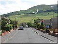
Swanston Place, looking south
A late-1950s private housing estate on the southern outskirts of Edinburgh. Beyond my means when looking to buy my first house on arrival in Edinburgh in 1964 - £4000 for a detached 3-bedroom house; I had to make do with a semi for £3650. Looking towards Lothianburn golf course and the Hillend ski-centre on the slopes of Caerketton Hill.
Image: © M J Richardson
Taken: 7 Jul 2010
0.12 miles
3
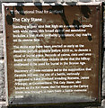
Plaque at the Caiy Stone
This is self-explanatory, and refers to Image There is, however, a school of thought that the Camus Stone was not an alternative name for the Caiy Stane, but a different stone, now lost.
Image: © Anne Burgess
Taken: 5 Jun 2016
0.13 miles
4

Caiy Stane
See https://canmore.org.uk/site/51756/caiy-stane and Image] for details of the Caiy Stane, and Image A whole network of adjacent streets is named after the stone.
Image: © Anne Burgess
Taken: 5 Jun 2016
0.13 miles
5

Cup Marks on Caiy Stane
Although the descriptions say there are six cup marks on the Image], only five are obvious. I see that some idiot has seen fit to spray the stone with paint.
Image: © Anne Burgess
Taken: 5 Jun 2016
0.13 miles

7

Road junction, Swanston
Caiyside (L) meets Swanston Road in a suburban residential area on the southern fringe of Edinburgh. Hillend ski slope is in the background on the flank of Caerketton.
Image: © Jim Barton
Taken: 22 Sep 2017
0.14 miles
8
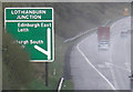
A720 Edinburgh Bypass
Looking east on a wet afternoon.
Image: © michael ely
Taken: 15 Oct 2008
0.15 miles

10

The Caiy Stane
About 3m high, the Caiy Stane is a broad slab of red sandstone possibly marking a ritual or burial place from Neolithic times. The hilltop where it is sited continued to be used in the Bronze Age, and it may also have been the site of a battle in more recent times, with the stone as a memorial. The reverse face has six, probably prehistoric cup marks, some old graffiti and some more recent spray-painted defacings.
Image: © M J Richardson
Taken: 15 Aug 2007
0.16 miles