
IMAGES TAKEN NEAR TO
Braid Road, EDINBURGH, EH10 6AW
Introduction
This page details the photographs taken nearby to Braid Road, EH10 6AW by members of the Geograph project.
The Geograph project started in 2005 with the aim of publishing, organising and preserving representative images for every square kilometre of Great Britain, Ireland and the Isle of Man.

There are currently over 7.5m images from over14,400 individuals and you can help contribute to the project by visiting https://www.geograph.org.uk
Image Map
Images are licensed for reuse under creativecommons.org/licenses/by-sa/2.0
Notes
- Clicking on the map will re-center to the selected point.
- The higher the marker number, the further away the image location is from the centre of the postcode.
Image Listing (274 Images Found)
Images are licensed for reuse under creativecommons.org/licenses/by-sa/2.0
Image
Details
Distance
1

Braid Crescent
Looking east - snowbound for about four days now, and nothing much moving, apart from the one car not having much luck at getting out.
Image: © M J Richardson
Taken: 1 Dec 2010
0.03 miles
2

'The Hanging Stanes'
A plaque set into the adjacent pavement here at Braid Road explains their significance:-
"Thomas Kelly and Henry O'R Neil, the last two highwaymen in Scotland to be executed, were hanged in public on the 26th January 1815 from the gallows erected on the two stanes still visible on the spot which was where the robbery took place."
Image: © ronnie leask
Taken: 26 Mar 2009
0.04 miles
3

Braid Burn, Hermitage
The Hermitage of Braid is a deep gorge below Blackford Hill and is now a park. The Braid Burn is rich in wildlife and a typical upland stream.
Image: © Richard Webb
Taken: 17 May 2005
0.04 miles
4
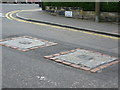
The Hanging Stanes, Braid Road
The bases for two gallows mark the site of Scotland's last execution for highway robbery on 25th January, 1815. The temporary gallows were erected specifically to hang two Irishmen, Thomas Kelly and Henry O'Neill, at the scene of their crime, on 25th January 1815.
See also Image
Image: © kim traynor
Taken: 21 Apr 2011
0.04 miles
5

Suburban Jackdaws
Two adults and a young bird [I think]. There is feeding and soliciting behaviour, and there is a nest in the roof, entered to the right between the lower and upper gutter levels, behind the RH downpipe.
Image: © M J Richardson
Taken: 18 Jun 2025
0.04 miles
6

OS Cut Mark Edinburgh, 2 Braid Crescent
OS Cut Mark Edinburgh, 2 Braid Crescent - nice clear cut mark
Image: © thejackrustles
Taken: 22 Nov 2015
0.05 miles
7

Comiston Rooftops.
Overlooking the tenements of Comiston Road, Comiston Gardens and Comiston Place from the chimneys of Comiston Terrace. The newer building in the centre is the Kennedy Tower, Royal Edinburgh Hospital. On the skyline to the right are Napier University and the spires of Holy Corner at Churchill.
Image: © Graeme Paterson
Taken: 18 Jun 2008
0.05 miles
8
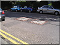
The Hanging Stanes, Braid Road
A plaque set in the pavement reads:- The Hanging Stanes. Thomas Kelly and Henry O'R Neil, the last two highwaymen in Scotland to be executed, were hanged in public on 25th January 1815, from the gallows erected on the two stanes still visible on the spot, which was where the robbery took place. 1993, paid for by public subscription [the plaque, not the execution!]
Image: © M J Richardson
Taken: 29 Aug 2007
0.06 miles
9

Looking west along Braid Crescent
From its crossing with Braid Road.
Image: © M J Richardson
Taken: 1 Dec 2010
0.06 miles
10
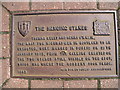
Plaque for the Hanging Stanes
For the Hanging Stanes [stones] see Image
Image: © M J Richardson
Taken: 29 Aug 2007
0.06 miles