IMAGES TAKEN NEAR TO
Temple, LONDON, EC4Y 7AX
Introduction
This page details the photographs taken nearby to Temple, EC4Y 7AX by members of the Geograph project.
The Geograph project started in 2005 with the aim of publishing, organising and preserving representative images for every square kilometre of Great Britain, Ireland and the Isle of Man.

There are currently over 7.5m images from over14,400 individuals and you can help contribute to the project by visiting https://www.geograph.org.uk
Image Map
Images are licensed for reuse under creativecommons.org/licenses/by-sa/2.0
Notes
- Clicking on the map will re-center to the selected point.
- The higher the marker number, the further away the image location is from the centre of the postcode.
Image Listing (2482 Images Found)
Images are licensed for reuse under creativecommons.org/licenses/by-sa/2.0
Image
Details
Distance
1
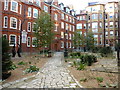
Hare Court, Inner Temple
Gravel garden.
"The name of this court commemorates Nicholas Hare (d. 1597), one of four bencher brothers, and Treasurer in 1584, who built chambers here; it was previously called the Little Court, or Garden Court, and is perhaps the same as Nut Tree Court, called the 'Nut Garden' in Henry VIII's time. It contained a well, with a pump. The original buildings here were named after various members who paid for their erection - for instance Crompton's Building and Brooker's Building - but after rebuilding in the seventeenth century they were all known by the name of the court itself." Quoted from http://www.innertemplelibrary.org.uk/temple-history/present-buildings/inner-temple-history-the-buildings-hare-court.htm
Image: © Peter Barr
Taken: 1 Nov 2011
0.01 miles
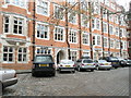
2
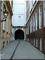
Inner Temple Lane
The Inner Temple is one of the four Inns of Court (the other three being Middle Temple, Gray's Inn and Lincoln's Inn). This lane leads past Image] to Inner Temple. The black door seen at the end of the lane leads out onto Fleet Street but was locked when we were there (unlike the one on Middle Temple see Image]).
The building on the left in this image is Dr Johnson's Buildings, while on the right is 17 Fleet Street.
Image: © Rob Farrow
Taken: 2 Mar 2013
0.01 miles
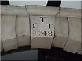
3
The Niblett Pegasus
To commemorate a benefactor whose generosity lives on in the buildings he funded.
Image: © Basher Eyre
Taken: 13 Apr 2008
0.01 miles
4
Postbox by Brick Court
So called because the buildings here were the first to be built of brick rather than wattle and daub. Number 2 and 3 were bombed in 1940. Goldsmith https://en.wikipedia.org/wiki/Oliver_Goldsmith and later Thackeray https://en.wikipedia.org/wiki/William_Makepeace_Thackeray both lived here
Long, D. (2021). London’s Secret Square Mile. 2nd ed. Cheltenham: The History Press.
Image: © Basher Eyre
Taken: 13 Apr 2008
0.01 miles
5
Boundary of the Cities of Westminster and London at Devereux Court
Named after Robert Devereux, Earl of Essex, whose townhouse was demolished in 1670. A bust of the great man looks down from the eponymous pub.
Long, D. (2021). London’s Secret Square Mile. 2nd ed. Cheltenham: The History Press.
Image: © Basher Eyre
Taken: 14 Sep 2008
0.01 miles
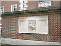
7
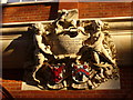
Temple Grandeur
Ornate plaque with coats-of-arms (1893-4) in the Inner Temple Inn of Court. The winged horse, Pegasus, is the badge of the Inner Temple.
Image: © Colin Smith
Taken: 4 Jan 2010
0.02 miles
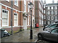
8
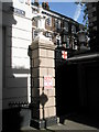
Parish boundary mark in Fleet Street
For The Temple Church http://en.wikipedia.org/wiki/Temple_Church
Image: © Basher Eyre
Taken: 25 Feb 2013
0.02 miles
9
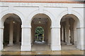
Arches opposite Temple Church, London EC4
These arches are opposite Temple Church.
Image: © Christine Matthews
Taken: 1 Oct 2012
0.02 miles
10
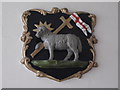
Lamb and flag
Plaque in Middle Temple Lane, EC4.
Image: © Mike Quinn
Taken: 15 Jan 2009
0.02 miles