IMAGES TAKEN NEAR TO
Black Friars Lane, LONDON, EC4V 6EB
Introduction
This page details the photographs taken nearby to Black Friars Lane, EC4V 6EB by members of the Geograph project.
The Geograph project started in 2005 with the aim of publishing, organising and preserving representative images for every square kilometre of Great Britain, Ireland and the Isle of Man.

There are currently over 7.5m images from over14,400 individuals and you can help contribute to the project by visiting https://www.geograph.org.uk
Image Map
Images are licensed for reuse under creativecommons.org/licenses/by-sa/2.0
Notes
- Clicking on the map will re-center to the selected point.
- The higher the marker number, the further away the image location is from the centre of the postcode.
Image Listing (3083 Images Found)
Images are licensed for reuse under creativecommons.org/licenses/by-sa/2.0
Image
Details
Distance
1
A different sort of Global Warming (93)
Blackfriars Lane
Image: © Basher Eyre
Taken: 29 Oct 2017
0.01 miles
2
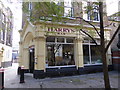
A different sort of Global Warming (98)
Pizzeria in Blackfriars Lane
Image: © Basher Eyre
Taken: 29 Oct 2017
0.01 miles
3
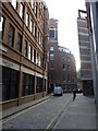
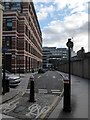
A different sort of Global Warming (97)
Looking south-west down Blackfriars Lane
Image: © Basher Eyre
Taken: 29 Oct 2017
0.01 miles
4
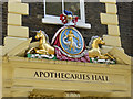
Arms above door, Apothecaries Hall
On Black Friars Lane, EC4.
Image: © Robin Webster
Taken: 22 Apr 2018
0.01 miles
5
A different sort of Global Warming (99)
Junction of Apothecary Street and Playhouse Yard http://www.shakespearesglobe.com/uploads/files/2013/10/playhouses.pdf
Image: © Basher Eyre
Taken: 29 Oct 2017
0.01 miles
6

Apothecaries Hall
Apothecaries Hall is a scheduled monument in Black Friars Lane, London. It is the headquarters of the Worshipful Society of Apothecaries of London, one of the livery companies of the City of London.
Image: © Peter Trimming
Taken: 12 Jun 2021
0.01 miles

8
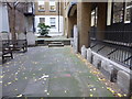
Gravestones in the former churchyard of St Anne Blackfriars
The garden covers part of the original medieval Dominican Priory of Blackfriars, which stood on this site until it was dissolved in 1538. The priory was replaced by the parish church of St Anne Blackfriars until this in turn was destroyed by the Great Fire of 1666 when the parish was united with St Andrew-by-the Wardrobe.
The area was used as a churchyard until 1849. The level has been raised by the enormous number of burials which took place here in the 18th and 19th centuries. A crumbling section of wall is a surviving fragment from the Priory of the Dominicans. The garden has been maintained since 1964 by the Corporation of London.
Image: © Marathon
Taken: 6 Dec 2017
0.01 miles
9
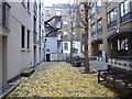
The former churchyard of St Anne Blackfriars
The garden covers part of the original medieval Dominican Priory of Blackfriars, which stood on this site until it was dissolved in 1538. The priory was replaced by the parish church of St Anne Blackfriars until this in turn was destroyed by the Great Fire of 1666 when the parish was united with St Andrew-by-the Wardrobe.
The area was used as a churchyard until 1849. The level has been raised by the enormous number of burials which took place here in the 18th and 19th centuries. A crumbling section of wall is a surviving fragment from the Priory of the Dominicans. The garden has been maintained since 1964 by the Corporation of London.
Image: © Marathon
Taken: 6 Dec 2017
0.01 miles
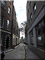
10
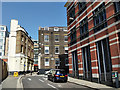
Black Friars Lane, EC4
Leading to Playhouse Yard on the right.
Image: © Robin Webster
Taken: 22 Apr 2018
0.02 miles