IMAGES TAKEN NEAR TO
Priory Court, Pilgrim Street, LONDON, EC4V 6DE
Introduction
This page details the photographs taken nearby to Priory Court, Pilgrim Street, EC4V 6DE by members of the Geograph project.
The Geograph project started in 2005 with the aim of publishing, organising and preserving representative images for every square kilometre of Great Britain, Ireland and the Isle of Man.

There are currently over 7.5m images from over14,400 individuals and you can help contribute to the project by visiting https://www.geograph.org.uk
Image Map
Images are licensed for reuse under creativecommons.org/licenses/by-sa/2.0
Notes
- Clicking on the map will re-center to the selected point.
- The higher the marker number, the further away the image location is from the centre of the postcode.
Image Listing (3241 Images Found)
Images are licensed for reuse under creativecommons.org/licenses/by-sa/2.0
Image
Details
Distance
1
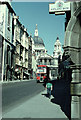
Ludgate Hill, 1959
Looking up Ludgate Hill towards St. Paul's. Picture taken in 1959 and scanned from an old Agfacolor slide. The bus is, I am advised, an RTL type (rarer than RT). It is a No. 6 going to Kensal Rise Station. Interesting to compare this with the 2005 picture.
Image: © David Wright
Taken: Unknown
0.00 miles
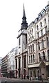
4
View from St Paul's Cathedral, 1976 (2)
View along Ludgate Hill.
Image: © Harold Dilworth Crewdson
Taken: Unknown
0.00 miles
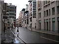
7
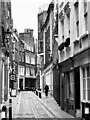
A-spiring to find a hundred churches (110)
Looking along Carter Lane, which before the Great Fire was in the parish of St Ann Blackfriars https://en.wikipedia.org/wiki/St_Ann_Blackfriars
Image: © Basher Eyre
Taken: 20 Nov 2016
0.02 miles
8
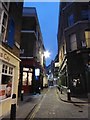
A different sort of Global Warming (92)
Looking from Ludgate Broadway into Cobb's Court, so called after a shady Mayor of Bedford. Until the Great Fire of 1666 this area was occupied by St Ann, Blackfriars. When that church was not rebuilt it became a thoroughfare- the far portion was called "Postboy Passage"until 1746.
Long, D. (2021). London’s Secret Square Mile. 2nd ed. Cheltenham: The History Press.
Image: © Basher Eyre
Taken: 29 Oct 2017
0.02 miles
9
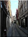
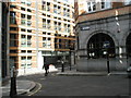
City of London: Carter Lane
A typical City of London side-street.
Image: © Chris Downer
Taken: 28 Jun 2008
0.02 miles
10
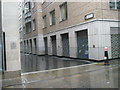
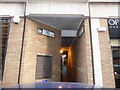
Junction of Pilgrim Street and Waithman Street
Taken on the Pepys Walk, a circular walk around the City of London and the South bank starting and finishing at St Paul's Cathedral.
Image: © Basher Eyre
Taken: 17 Apr 2009
0.02 miles