1
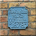
Ward boundary marker, St Andrew's Hill
Such is the dynamic nature of democracy in the City of London that this is still the boundary of Farringdon Within today.
Image: © Keith Edkins
Taken: 15 May 2009
0.00 miles
2
Carter Lane
Image: © N Chadwick
Taken: 23 Oct 2014
0.00 miles
3
Ludgate Square
Image: © Basher Eyre
Taken: 19 Jul 2008
0.00 miles
4
Old Boundary Marker by Burgon Street, City of London Parish
Parish Boundary Marker by the UC road, in parish of City of London (City of London District), Burgon Street EC4, at corner with Carter Lane high up on East wall of Burgon Street.
Surveyed
Milestone Society National ID: CL_WFAW03pb
Image: © Milestone Society
Taken: Unknown
0.01 miles
5
Old Boundary Marker by Creed Lane, City of London
Parish Boundary Marker by the UC road, in parish of City of London (City of London District), Creed Lane EC4, at corner of Carter Lane high up on wall.
Surveyed
Milestone Society National ID: CL_WFAW02pb
Image: © Milestone Society
Taken: Unknown
0.01 miles
6
Junction of Ludgate Square and Creed Lane
Image: © Basher Eyre
Taken: 19 Jul 2008
0.01 miles
7
Ludgate Hill looking towards Creed Lane
Rather confusingly this narrow street is also called Ludgate Hill as well as the better known west approach to St. Paul's cathedral.
Image: © Jonathan Thacker
Taken: 17 Mar 2012
0.01 miles
8
Traditional barbers in Carter Lane
Carter Lane was the site of Blackfriars Priory. It was scheduled to be destroyed in the 1970s but won a reprieve.
Long, D. (2021). London’s Secret Square Mile. 2nd ed. Cheltenham: The History Press.
Image: © Basher Eyre
Taken: 13 Apr 2008
0.01 miles
9
Old Boundary Marker by St Andrews Hill, City of London Parish
Parish Boundary Marker by the UC road, in parish of City Of London (City Of London District), St. Andrews Hill EC4, at corner with Carter Lane, high up on wall.
Surveyed
Milestone Society National ID: CL_WFAW01pb
Image: © Milestone Society
Taken: Unknown
0.01 miles
10
Pilgrim Street, London EC4
Image: © John Salmon
Taken: 9 Mar 2009
0.01 miles


