IMAGES TAKEN NEAR TO
Lime Street, LONDON, EC3M 7AA
Introduction
This page details the photographs taken nearby to Lime Street, EC3M 7AA by members of the Geograph project.
The Geograph project started in 2005 with the aim of publishing, organising and preserving representative images for every square kilometre of Great Britain, Ireland and the Isle of Man.

There are currently over 7.5m images from over14,400 individuals and you can help contribute to the project by visiting https://www.geograph.org.uk
Image Map (Loading...)


Getting Data...Please wait
Leaflet Map data © OpenStreetMap
Images are licensed for reuse under creativecommons.org/licenses/by-sa/2.0
Notes
- Clicking on the map will re-center to the selected point.
- The higher the marker number, the further away the image location is from the centre of the postcode.
Image Listing (4464 Images Found)
Images are licensed for reuse under creativecommons.org/licenses/by-sa/2.0
Image
Details
Distance
1
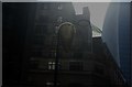
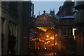
View of Mhairi Vari's "Support for a Cloud" at the top of a lamp post on Lime Street
Mhairi Vari's "Support for a Cloud" is in three different locations: one piece is at the top of a lamp post and the other two are on the side of the Lloyd's Building. It is an outdoor TV aerial covered in wire coat hangers, and greenhouse/poly-tunnel repair tape. It plays across ideas of micro and macro and references aspects of natural science, from cosmological formation to insect cocoons. The artwork is intended to inhabit the urban environment with its alien, nest-like structures that play on synthetic/organic forms. The surface of the "cocoons" has been created with loops of tape. The surface is alluring as it catches both daylight and artificial light, which further bring the work to life. The works are like small pieces of architecture inhabiting the man made environment like nests or protective cocoons. Looking south-southeast.
Image: © Robert Lamb
Taken: 21 Apr 2018
0.00 miles
2
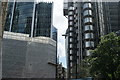
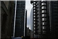
View of the Shard from St. Mary Axe
The Shard makes its first appearance on the City of London Designs walk I was on, creating quite a contrast with the Lloyds Building from the 1980s on the right. Looking south-southwest.
Image: © Robert Lamb
Taken: 8 Jun 2014
0.01 miles
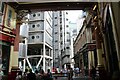
3
View under the canopy of the Willis Building
Looking north-northeast.
Image: © Robert Lamb
Taken: 26 Sep 2015
0.01 miles
4
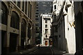
View down Leadenhall Place from inside Leadenhall Market
Looking south-southeast.
Image: © Robert Lamb
Taken: 8 Jun 2014
0.01 miles
5
View of Leadenhall Market from Leadenhall Place
Looking north-northwest.
Image: © Robert Lamb
Taken: 5 Mar 2016
0.01 miles
6
View of the Lloyds Building from Leadenhall Place
Looking south-southeast.
Image: © Robert Lamb
Taken: 29 Jun 2024
0.01 miles
7
View back down Leadenhall Place from Lime Street
Looking north-northwest.
Image: © Robert Lamb
Taken: 29 Jun 2024
0.01 miles
8
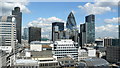
Looking North From The Monument
A wide variety of building styles in evidence, including the distinctive "Gherkin" (30 St Mary Axe). As a comparison, The Monument stands at 202 feet (61 metres) and the "Gherkin" 591 feet (180 metres).
The buildings closest to camera are in this gridsquare, but most of the buildings are in the adjacent gridsquare.
Image: © Peter Trimming
Taken: 1 May 2009
0.01 miles
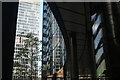
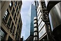
9
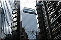
View of the Walkie Talkie building between the Willis and Lloyds buildings #2
Looking south-southwest.
Image: © Robert Lamb
Taken: 1 Feb 2015
0.01 miles
10
View of the Walkie Talkie building between the Willis and Lloyds buildings
Looking south-southwest.
Image: © Robert Lamb
Taken: 1 Feb 2015
0.01 miles