1
The Square Mile in one day (winter 61)
Looking from London Wall into Copthall Avenue
Image: © Basher Eyre
Taken: 20 Nov 2016
0.00 miles
2
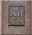
Old Boundary Marker off the A1211, 25 Copthall Avenue, off London Wall EC2
Parish Boundary Marker off the A1211, in parish of City Of London (City Of London District), London Wall EC2, high on wall of 25 Copthall Avenue, modern building, on granite cladding.
Surveyed
Milestone Society National ID: CL_SSC01pb.
Image: © Milestone Society
Taken: Unknown
0.01 miles
3
Great Winchester Street, City of London
Image: © David Howard
Taken: 25 Sep 2016
0.01 miles
4
Great Swan Alley
Image: © Basher Eyre
Taken: 8 Apr 2010
0.01 miles
5
Old Boundary Marker by the A1211, Copthall Avenue, off London Wall EC2
Parish Boundary Marker by the A1211, in parish of City Of London (City Of London District), London Wall EC2, high on wall of 25 Copthall Ave, modern building, on granite cladding.
Inscription reads:- : W / AH / 1799 :
Surveyed
Milestone Society National ID: CL_AHW02pb.
Image: © Milestone Society
Taken: Unknown
0.01 miles
6
Top end of Copthall Avenue
Image: © Basher Eyre
Taken: 8 Apr 2010
0.01 miles
7
Finsbury Circus: Salisbury House, EC2
Finsbury Circus was once the home to many Georgian residences. However the pressure to develop larger, corporate buildings in the late nineteenth century led to the demolition of many domestic scale Georgian buildings. None of the Georgian houses that once stood on Finsbury Circus remain. The area became the focus for several important British companies who designed and built headquarters around the Circus. Similar to other developments in the City at this time, these buildings were classically inspired and the buildings on Finsbury Circus were amongst the largest to be built in the area at that time. Salisbury House, designed by Davis and Emmanuel in 1899-1901, occupies the south west quadrant of the Circus.
Image: © Nigel Cox
Taken: 6 Nov 2007
0.02 miles
8
The City: banking on better weather (175)
Looking southwards down Copthall Avenue
Image: © Basher Eyre
Taken: 11 Sep 2023
0.02 miles
9
Moorgate Place
Image: © Basher Eyre
Taken: 8 Apr 2010
0.02 miles
10
The City: banking on better weather (177)
Looking northwards up Copthall Avenue
Image: © Basher Eyre
Taken: 11 Sep 2023
0.02 miles


