IMAGES TAKEN NEAR TO
Tabernacle Street, LONDON, EC2A 4LR
Introduction
This page details the photographs taken nearby to Tabernacle Street, EC2A 4LR by members of the Geograph project.
The Geograph project started in 2005 with the aim of publishing, organising and preserving representative images for every square kilometre of Great Britain, Ireland and the Isle of Man.

There are currently over 7.5m images from over14,400 individuals and you can help contribute to the project by visiting https://www.geograph.org.uk
Image Map
Images are licensed for reuse under creativecommons.org/licenses/by-sa/2.0
Notes
- Clicking on the map will re-center to the selected point.
- The higher the marker number, the further away the image location is from the centre of the postcode.
Image Listing (821 Images Found)
Images are licensed for reuse under creativecommons.org/licenses/by-sa/2.0
Image
Details
Distance
1
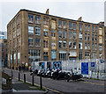
Former manufactory and warehouse, Shoreditch
The south Shoreditch area was once a centre of furniture manufactory, and many of the buildings associated with the industry remain. The image shows the rear view of the building once occupied by Lebus of Tabernacle Street. For a full account of the furniture trade in the Shoreditch area see this https://content.historicengland.org.uk/images-books/publications/behind-the-veneer-south-shoreditch/behind-the-veneer.pdf/.
Image: © Jim Osley
Taken: 6 Feb 2017
0.01 miles
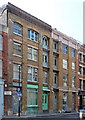
2
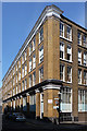
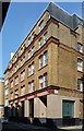
62-72 Tabernacle Street
This former Victorian warehouse is currently used by a number of textile and design companies. A plain but solidly attractive building.
A small sign above the 30mph sign informs us that Clere Street was formerly known as Paradise Street. This would appear to be a considerable downgrading, but having seen the street, the previous name must have been a constant source of disappointment.
Image: © Stephen Richards
Taken: 4 Jun 2011
0.01 miles
3
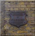
Old Boundary Marker by Clere Street, Finsbury
Municipal Boundary Marker by the UC road, in parish of Finsbury (Islington District), Clere Street EC2, at corner of private road to car park, opposite Fitzroy House.
Removed between May 2017 and May 2019.
Inscription reads:-
BOROUGH
OF
FINSBURY
BOUNDARY
{date}
Surveyed
Milestone Society National ID: MX_FINS07pb
Image: © Milestone Society
Taken: Unknown
0.02 miles
4
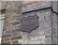
Old Boundary Marker by Tabernacle Street, Finsbury parish
Municipal Boundary Marker by the UC road, in parish of Finsbury (Islington District), on No. 76 Tabernacle Street EC2, at the corner with Clere Place private access road.
Surveyed
Milestone Society National ID: MX_FINS06pb
Image: © Milestone Society
Taken: Unknown
0.02 miles
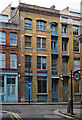
5
43-47 Tabernacle Street
One of many former Victorian warehouses in the area which has found a new lease of life, in this case as flats.
As a rule, these buildings are built of brick, of four or five storeys, with facades composed of generous windows (those on the top floor sometimes arched) divided by full-height piers or columns.
Image: © Stephen Richards
Taken: 4 Jun 2011
0.02 miles
6
Former furniture warehouse building, Tabernacle Street, Shoreditch
Image: © Jim Osley
Taken: 6 Feb 2017
0.03 miles
7
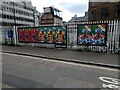
View of street art on Leonard Street
Looking south-southeast.
Image: © Robert Lamb
Taken: 11 Apr 2021
0.03 miles
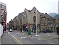
8
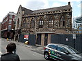
View of a church-like building on the corner of Tabernacle Street and Leonard Street
Looking south-southwest.
Image: © Robert Lamb
Taken: 11 Apr 2021
0.03 miles
9
52-58 Tabernacle Street
Probably one of many former Victorian warehouses in the area which has found a new lease of life, in this case as offices. It is now called Friendly House. The ground floor is clearly modern.
Image: © Stephen Richards
Taken: 4 Jun 2011
0.03 miles
10
Shoreditch, Central Foundation Boys' School
The site at the corner of Leonard and Tabernacle Streets: http://www.centralfoundationboys.co.uk/
Image: © Mike Faherty
Taken: 23 Feb 2014
0.04 miles