IMAGES TAKEN NEAR TO
City Road, LONDON, EC1Y 2AL
Introduction
This page details the photographs taken nearby to City Road, EC1Y 2AL by members of the Geograph project.
The Geograph project started in 2005 with the aim of publishing, organising and preserving representative images for every square kilometre of Great Britain, Ireland and the Isle of Man.

There are currently over 7.5m images from over14,400 individuals and you can help contribute to the project by visiting https://www.geograph.org.uk
Image Map
Images are licensed for reuse under creativecommons.org/licenses/by-sa/2.0
Notes
- Clicking on the map will re-center to the selected point.
- The higher the marker number, the further away the image location is from the centre of the postcode.
Image Listing (750 Images Found)
Images are licensed for reuse under creativecommons.org/licenses/by-sa/2.0
Image
Details
Distance
1
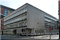
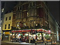
58-64 City Road
Probably dating from the 1960s, known as Monmouth House, with the standard ribbon windows, coloured spandrels, and stone elevations. A single piloti stands at the corner, which seems somewhat tokenistic. The building's relative lack of height means it may slip by under the radar of the rabid anti-1960s brigade.
Image: © Stephen Richards
Taken: 4 Jun 2011
0.01 miles
2
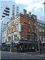
Leonard Street at the junction of City Road
Image: © David Howard
Taken: 25 Sep 2016
0.01 miles
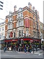

8
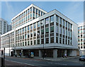
55-71 City Road
Large roughly U-shaped office complex, currently called Pembroke House, with a series of interlocking blocks of different heights. Under the windows are what looks like roughcast panels. It probably dates from the 1960s/1970s.
Image: © Stephen Richards
Taken: 4 Jun 2011
0.03 miles
9
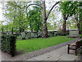
Bunhill Fields Burial Ground, City Road, London EC1
Looking north across the burial ground. Some of the City office blocks can be seen in the distance.
Image: © Christine Matthews
Taken: 7 May 2010
0.03 miles
10

Bunhill Fields public garden
The open space to the north of the graves, which are tightly packed within a fenced area, is a pleasant sylvan oasis where office workers can eat their lunch, take their ease or talk on their mobile phones.
Image: © Natasha Ceridwen de Chroustchoff
Taken: 23 Apr 2008
0.03 miles