IMAGES TAKEN NEAR TO
Tudor Road, LONDON, E9 7TE
Introduction
This page details the photographs taken nearby to Tudor Road, E9 7TE by members of the Geograph project.
The Geograph project started in 2005 with the aim of publishing, organising and preserving representative images for every square kilometre of Great Britain, Ireland and the Isle of Man.

There are currently over 7.5m images from over14,400 individuals and you can help contribute to the project by visiting https://www.geograph.org.uk
Image Map (Loading...)


Getting Data...Please wait
Leaflet Map data © OpenStreetMap
Images are licensed for reuse under creativecommons.org/licenses/by-sa/2.0
Notes
- Clicking on the map will re-center to the selected point.
- The higher the marker number, the further away the image location is from the centre of the postcode.
Image Listing (169 Images Found)
Images are licensed for reuse under creativecommons.org/licenses/by-sa/2.0
Image
Details
Distance
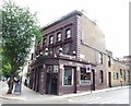
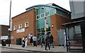
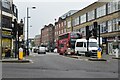
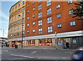
3
The London Fields, Public House, Hackney
On the junction of Mare Street (in front) and Warbuton Road (on the right).
Image: © David Anstiss
Taken: 15 Feb 2012
0.04 miles
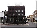
5
Cattle Trough, Mare Street
Grade II listed stone cattle trough just north of the junction with Westgate Street.
See http://www.britishlistedbuildings.co.uk/en-424430-trough-just-north-of-junction-with-westg for more details.
Image: © David Anstiss
Taken: 15 Feb 2012
0.05 miles
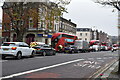
7
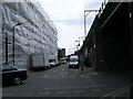
Under the arches, London Fields Train station
Image: © Isaac Letterhead
Taken: 25 Jul 2008
0.05 miles