IMAGES TAKEN NEAR TO
Park Close, LONDON, E9 7LF
Introduction
This page details the photographs taken nearby to Park Close, E9 7LF by members of the Geograph project.
The Geograph project started in 2005 with the aim of publishing, organising and preserving representative images for every square kilometre of Great Britain, Ireland and the Isle of Man.

There are currently over 7.5m images from over14,400 individuals and you can help contribute to the project by visiting https://www.geograph.org.uk
Image Map (Loading...)


Getting Data...Please wait
Leaflet Map data © OpenStreetMap
Images are licensed for reuse under creativecommons.org/licenses/by-sa/2.0
Notes
- Clicking on the map will re-center to the selected point.
- The higher the marker number, the further away the image location is from the centre of the postcode.
Image Listing (136 Images Found)
Images are licensed for reuse under creativecommons.org/licenses/by-sa/2.0
Image
Details
Distance
2
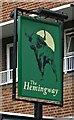
Sign for the Hemingway, Hackney, London
See Image] for context.
Image: © JThomas
Taken: 22 Aug 2022
0.04 miles
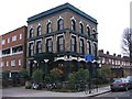
4
The Hemingway, Hackney, London
On Victoria Park Road, London E9.
See Image] for sign.
Image: © JThomas
Taken: 22 Aug 2022
0.05 miles
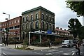
10
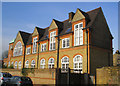
Victoria Park Lofts, Rutland Road, South Hackney
The annexe of the former Lauriston School was converted to make these stylish apartments.
Image: © Dr Neil Clifton
Taken: 22 Jan 2008
0.10 miles