IMAGES TAKEN NEAR TO
Parkside Estate, Rutland Road, LONDON, E9 7JX
Introduction
This page details the photographs taken nearby to Parkside Estate, Rutland Road, E9 7JX by members of the Geograph project.
The Geograph project started in 2005 with the aim of publishing, organising and preserving representative images for every square kilometre of Great Britain, Ireland and the Isle of Man.

There are currently over 7.5m images from over14,400 individuals and you can help contribute to the project by visiting https://www.geograph.org.uk
Image Map (Loading...)


Getting Data...Please wait
Leaflet Map data © OpenStreetMap
Images are licensed for reuse under creativecommons.org/licenses/by-sa/2.0
Notes
- Clicking on the map will re-center to the selected point.
- The higher the marker number, the further away the image location is from the centre of the postcode.
Image Listing (197 Images Found)
Images are licensed for reuse under creativecommons.org/licenses/by-sa/2.0
Image
Details
Distance
1
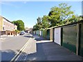
South Hackney, garages
Lock-up garages on Morpeth Road.
Image: © Mike Faherty
Taken: 8 Sep 2012
0.01 miles
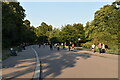
2
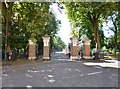
Victoria Park, Gore Gate
Entrance to the park from Gore Road.
Image: © Mike Faherty
Taken: 8 Sep 2012
0.05 miles
3
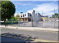
South Hackney, Lauriston Primary School
As seen from Morpeth Road. http://lauriston.hackney.sch.uk.172-30-178-41.psk-preview.lgfl.org.uk/
Image: © Mike Faherty
Taken: 8 Sep 2012
0.05 miles
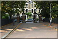
6
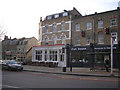
The 'Empress' public house, Lauriston Road, South Hackney
Smokers are well provided for, with a large number of chairs and tables outside this Victorian pub.
Image: © Dr Neil Clifton
Taken: 22 Jan 2008
0.08 miles

8
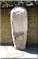
Old Boundary Marker
Parish Boundary Marker against the front wall of No 144 Lauriston Road, South Hackney E9, on the west side of the road, near the junction with Morpeth Road. Inscribed 1 (date?) / … / … / CHURCHWARDENS / …. The inscription is almost illegible and there is severe erosion or damage above the base.
Milestone Society National ID: MX_SMBG06pb
Image: © M Faherty
Taken: 8 Sep 2012
0.09 miles
10
Jewish burial ground, Lauriston Road, South Hackney
This small burial ground has been closed to burials for over 100 years. To enter it, a special appointment must be made. At one time, there was a large population of Jewish people in Hackney, but at present there are far fewer.
Image: © Dr Neil Clifton
Taken: 22 Jan 2008
0.09 miles