IMAGES TAKEN NEAR TO
Balcorne Street, LONDON, E9 7JW
Introduction
This page details the photographs taken nearby to Balcorne Street, E9 7JW by members of the Geograph project.
The Geograph project started in 2005 with the aim of publishing, organising and preserving representative images for every square kilometre of Great Britain, Ireland and the Isle of Man.

There are currently over 7.5m images from over14,400 individuals and you can help contribute to the project by visiting https://www.geograph.org.uk
Image Map
Images are licensed for reuse under creativecommons.org/licenses/by-sa/2.0
Notes
- Clicking on the map will re-center to the selected point.
- The higher the marker number, the further away the image location is from the centre of the postcode.
Image Listing (115 Images Found)
Images are licensed for reuse under creativecommons.org/licenses/by-sa/2.0
Image
Details
Distance
1
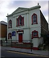
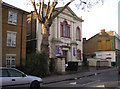
Hampden Chapel (Assemblies of God) Pentecostal Church, Lauriston Road
Grade II Non-conformist place of worship http://www.britishlistedbuildings.co.uk/en-424389-hampden-chapel-hackney
Image: © Jim Osley
Taken: 28 Jan 2011
0.04 miles
2
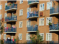
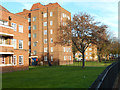
Sherard House, Frampton Park Estate
These flats overlook Frampton Park Road just off Well street in Hackney. Frampton Park Estate was built for the London County Council in the 1950s on land largely devastated by wartime bombing. In more recent years it acquired a fearful reputation for gang-related violence although everything here seems pleasant enough in the sunshine.
Image: © Stephen McKay
Taken: 20 Nov 2015
0.06 miles
3
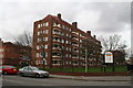
Frampton Park Estate, Hackney
The very large Frampton Park Estate, of which the above shows only one house, extends for many acres from Well Street right round to Mare Street to the north west. These well-built flats are now under the supervision of a Housing Association Trust.
Image: © Dr Neil Clifton
Taken: 24 Jan 2008
0.07 miles
4
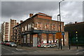
The 'Frampton Arms', Well Street, Hackney
Yet another London pub which has gone to the wall. It surprises me that there were not enough customers from the nearby Frampton Park Estate to keep it in business.
Image: © Dr Neil Clifton
Taken: 24 Jan 2008
0.07 miles
5
Hampden Chapel, Lauriston Road, South Hackney
Built in 1847 as a Baptist chapel, but now an Assemblies of God church. The 'Albion' public house is seen in the right background.
Image: © Dr Neil Clifton
Taken: 22 Jan 2008
0.08 miles
6
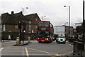
Route 277 bus, Well Street, South Hackney
The bus is at the junction of Well Street and Lauriston Road, and it represents a link with the past, for Route 277 can trace its ancestry directly back, via the 677 trolleybus and the 77 electric tram, to the horse tramway which began in 1869 and ran from Cassland Road to Limehouse. The present 277 goes from Highbury and Islington station to Leamouth.
Image: © Dr Neil Clifton
Taken: 24 Jan 2008
0.09 miles
8
Frampton Park Estate
Part of a 1950s former London County Council housing estate seen from Well Street.
Image: © Stephen McKay
Taken: 20 Nov 2015
0.09 miles
9
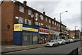
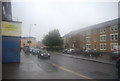
Shopping parade, Well Street, South Hackney
This appears to be a post-WW2 replacement for older property. At the far end on the left, there was previously a cinema.
Image: © Dr Neil Clifton
Taken: 24 Jan 2008
0.10 miles
10
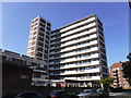
Tradescant House, Hackney
Tradescant House is an 11-storey block containing 60 dwellings on the Frampton Park council housing estate in Hackney, east London.
Image: © Richard Rogerson
Taken: 22 Aug 2019
0.10 miles