IMAGES TAKEN NEAR TO
Lauriston Road, LONDON, E9 7HA
Introduction
This page details the photographs taken nearby to Lauriston Road, E9 7HA by members of the Geograph project.
The Geograph project started in 2005 with the aim of publishing, organising and preserving representative images for every square kilometre of Great Britain, Ireland and the Isle of Man.

There are currently over 7.5m images from over14,400 individuals and you can help contribute to the project by visiting https://www.geograph.org.uk
Image Map (Loading...)


Getting Data...Please wait
Leaflet Map data © OpenStreetMap
Images are licensed for reuse under creativecommons.org/licenses/by-sa/2.0
Notes
- Clicking on the map will re-center to the selected point.
- The higher the marker number, the further away the image location is from the centre of the postcode.
Image Listing (133 Images Found)
Images are licensed for reuse under creativecommons.org/licenses/by-sa/2.0
Image
Details
Distance
5
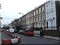
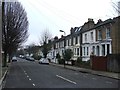
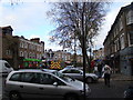
Lauriston Road, South Hackney
St John of Jerusalem Church is behind.
Image: © Bill Boaden
Taken: 17 Mar 2016
0.05 miles
6
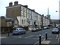
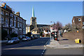
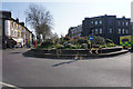
A South Hackney roundabout
On Victoria Park Road with Lauriston Road.
Image: © Ian S
Taken: 6 Dec 2010
0.07 miles
8
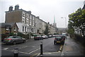
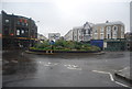
Roundabout in South Hackney
Lauriston Road and Grove Road meet Victoria Park Road at this roundabout.
Image: © Bill Boaden
Taken: 17 Mar 2016
0.07 miles
9
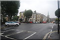
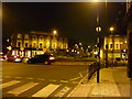
View of the Lauriston Road roundabout from Lauriston Road
Looking north-northwest.
Image: © Robert Lamb
Taken: 16 Dec 2011
0.07 miles