IMAGES TAKEN NEAR TO
Shore Road, LONDON, E9 7FL
Introduction
This page details the photographs taken nearby to Shore Road, E9 7FL by members of the Geograph project.
The Geograph project started in 2005 with the aim of publishing, organising and preserving representative images for every square kilometre of Great Britain, Ireland and the Isle of Man.

There are currently over 7.5m images from over14,400 individuals and you can help contribute to the project by visiting https://www.geograph.org.uk
Image Map
Images are licensed for reuse under creativecommons.org/licenses/by-sa/2.0
Notes
- Clicking on the map will re-center to the selected point.
- The higher the marker number, the further away the image location is from the centre of the postcode.
Image Listing (92 Images Found)
Images are licensed for reuse under creativecommons.org/licenses/by-sa/2.0
Image
Details
Distance
1
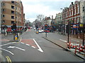
Mare street
Mare street approaching junction with Well street
Image: © Shaun Ferguson
Taken: 24 Sep 2008
0.08 miles
2
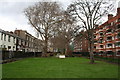
St. Thomas' Burial Ground, Well Street, Hackney
Although this burial ground has not been used as such for over a century, it makes a pleasant green space. St. Andrew's Hall used to occupy the area nearest to the camera.
Image: © Dr Neil Clifton
Taken: 24 Jan 2008
0.08 miles
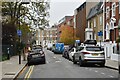
3
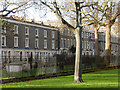
St Thomas's Place, Hackney
Houses on St Thomas's Place overlook St Thomas's burial ground, off Well Street. The burial ground was established in 1810 as the cemetery for a chapel-of-ease to St John at Hackney church. Burials ceased in 1876 and the site became a public garden as it still is today.
Image: © Stephen McKay
Taken: 20 Nov 2015
0.09 miles
5
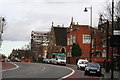
School and church, Mare Street, Hackney
The school at the right of the church was probably connected with it in some way, at the time when the church was Congregationalist. Pitcairn House (block of flats) is seen just beyond.
Image: © Dr Neil Clifton
Taken: 24 Jan 2008
0.10 miles


9
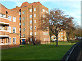
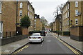
Frampton Park Estate
Part of a 1950s former London County Council housing estate seen from Well Street.
Image: © Stephen McKay
Taken: 20 Nov 2015
0.10 miles