IMAGES TAKEN NEAR TO
Iveagh Close, LONDON, E9 7BW
Introduction
This page details the photographs taken nearby to Iveagh Close, E9 7BW by members of the Geograph project.
The Geograph project started in 2005 with the aim of publishing, organising and preserving representative images for every square kilometre of Great Britain, Ireland and the Isle of Man.

There are currently over 7.5m images from over14,400 individuals and you can help contribute to the project by visiting https://www.geograph.org.uk
Image Map
Images are licensed for reuse under creativecommons.org/licenses/by-sa/2.0
Notes
- Clicking on the map will re-center to the selected point.
- The higher the marker number, the further away the image location is from the centre of the postcode.
Image Listing (122 Images Found)
Images are licensed for reuse under creativecommons.org/licenses/by-sa/2.0
Image
Details
Distance
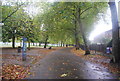
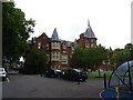
2
A small green area, Hackney
Between housing on Victoria Park Road, to the left, and Iveagh Close to the right. It really needs to be no larger, as the area is hard by the pleasant and extensive Victoria Park.
Image: © Robin Webster
Taken: 11 Dec 2010
0.05 miles
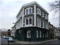
9
Mossbourne Victoria Park Academy
A coeducational secondary school.
Image: © JThomas
Taken: 22 Aug 2022
0.08 miles
10
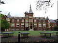
Mossbourne Victoria Park Academy
A coeducational secondary school.
Image: © JThomas
Taken: 22 Aug 2022
0.08 miles