IMAGES TAKEN NEAR TO
Frampton Park Road, LONDON, E9 6QL
Introduction
This page details the photographs taken nearby to Frampton Park Road, E9 6QL by members of the Geograph project.
The Geograph project started in 2005 with the aim of publishing, organising and preserving representative images for every square kilometre of Great Britain, Ireland and the Isle of Man.

There are currently over 7.5m images from over14,400 individuals and you can help contribute to the project by visiting https://www.geograph.org.uk
Image Map
Images are licensed for reuse under creativecommons.org/licenses/by-sa/2.0
Notes
- Clicking on the map will re-center to the selected point.
- The higher the marker number, the further away the image location is from the centre of the postcode.
Image Listing (115 Images Found)
Images are licensed for reuse under creativecommons.org/licenses/by-sa/2.0
Image
Details
Distance
3
Shore Gardens
A small area of surviving park.
Image: © Bill Boaden
Taken: 17 Mar 2016
0.07 miles
8
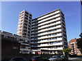
Tradescant House, Hackney
Tradescant House is an 11-storey block containing 60 dwellings on the Frampton Park council housing estate in Hackney, east London.
Image: © Richard Rogerson
Taken: 22 Aug 2019
0.09 miles