IMAGES TAKEN NEAR TO
Trelawney Estate, Paragon Road, LONDON, E9 6PG
Introduction
This page details the photographs taken nearby to Trelawney Estate, Paragon Road, E9 6PG by members of the Geograph project.
The Geograph project started in 2005 with the aim of publishing, organising and preserving representative images for every square kilometre of Great Britain, Ireland and the Isle of Man.

There are currently over 7.5m images from over14,400 individuals and you can help contribute to the project by visiting https://www.geograph.org.uk
Image Map (Loading...)


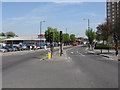
Getting Data...Please wait
Leaflet Map data © OpenStreetMap
Images are licensed for reuse under creativecommons.org/licenses/by-sa/2.0
Notes
- Clicking on the map will re-center to the selected point.
- The higher the marker number, the further away the image location is from the centre of the postcode.
Image Listing (234 Images Found)
Images are licensed for reuse under creativecommons.org/licenses/by-sa/2.0
Image
Details
Distance
4
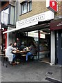
Alfresco dining, Temple of Hackney, London E9
Temple of Hackney is a vegan eatery at 10 Morning Lane London E9 6NA.
Image: © Sue Grayson
Taken: 14 Oct 2017
0.07 miles
5
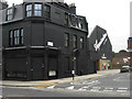
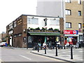
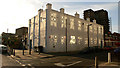
Chatham Place, Hackney
This striking black building stands at the junction of Morning Lane and Chatham Place. The Aquascutum factory shop offers a range of the company's products at significantly discounted prices.
Image: © Stephen McKay
Taken: 10 Jun 2013
0.08 miles
6
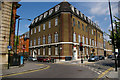
Post Office and Telephone Exchange, Paragon Road, Hackney, London E9
Large Post Office and Telephone Exchange, Paragon Road, Hackney, built about 1930 to the designs of Archibald Scott of the Office of Works. Although the post office has been closed for a while, the telephone exchange is still operational.
Image: © Jim Osley
Taken: 12 May 2010
0.09 miles
7
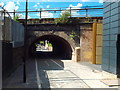
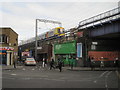
Cycle and pedestrian path, Hackney
A path for pedestrians and cyclists in Hackney, east London. The arch bridge carries the North London Line, a busy suburban railway.
Image: © Malc McDonald
Taken: 17 Jul 2016
0.09 miles
9
Belsham Street E9
The Celestial Church of Christ
Image: © geo sharples
Taken: 2 Jan 2007
0.10 miles
10
Hackney 1st railway station (site), Greater London
Opened in 1850 by the East & West India Docks and Birmingham Junction Railway, later the North London Railway, on the line from Camden Town to Bow, this station closed in 1870 when it was replaced by another station immediately behind the camera position (see Image).
View south east from Mare Street. The main building was in front of the first two arches with the platforms sticking out at the upper level. No trace now remains. For a fuller history, see http://www.disused-stations.org.uk/h/hackney/index0.shtml.
Image: © Nigel Thompson
Taken: 7 Feb 2017
0.10 miles