IMAGES TAKEN NEAR TO
Staveley Close, LONDON, E9 6DY
Introduction
This page details the photographs taken nearby to Staveley Close, E9 6DY by members of the Geograph project.
The Geograph project started in 2005 with the aim of publishing, organising and preserving representative images for every square kilometre of Great Britain, Ireland and the Isle of Man.

There are currently over 7.5m images from over14,400 individuals and you can help contribute to the project by visiting https://www.geograph.org.uk
Image Map
Images are licensed for reuse under creativecommons.org/licenses/by-sa/2.0
Notes
- Clicking on the map will re-center to the selected point.
- The higher the marker number, the further away the image location is from the centre of the postcode.
Image Listing (116 Images Found)
Images are licensed for reuse under creativecommons.org/licenses/by-sa/2.0
Image
Details
Distance
1
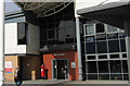
Homerton Hospital, Hackney
Homerton Hospital was opened in 1986 and became one of the first 10 NHS foundation trusts in England in 2004. Homerton is the designated hospital for the 2012 Olympics.
Image: © Julie Cookson
Taken: 14 Mar 2008
0.09 miles
2
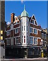
"The Plough" public house, Homerton High Street
Grade II listed public house, described at this https://historicengland.org.uk/listing/the-list/list-entry/1226765. (The date of building of 1808 recorded in the listing text his clearly incorrect).
Image: © Jim Osley
Taken: 17 Jul 2016
0.13 miles

4

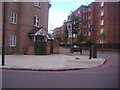
Homerton High Street
Looking towards Fenn Street
Image: © David Howard
Taken: 25 Jun 2024
0.14 miles
5
Fenn Street from Homerton High Street
I wonder if this inspired Please Sir and the Fenn Street Gang? It's the only one I've cone across and the series were set in London so possible.
Image: © David Howard
Taken: 11 Jul 2012
0.14 miles
6

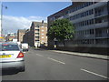
Homerton High Street
The City Academy is on the left behind the branches.
Image: © David Howard
Taken: 11 Jul 2012
0.14 miles
7
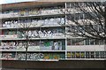
Homerton High Street
Ponsford Street is on the right between the blocks of flats
Image: © David Howard
Taken: 11 Jul 2012
0.14 miles
9
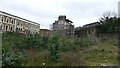
Behind Amhurst Road
Site of the old Gibbons of Hackney shop, burned down in 2003.
Image: © geo sharples
Taken: 15 Oct 2006
0.15 miles
10
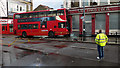
Lower Clapton road
View toward Median road obscured by a bus which has crashed into the Lord Cecil pub.
Image: © geo sharples
Taken: 1 Oct 2006
0.15 miles