1
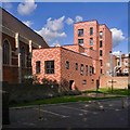
Mallard Close Flats on Osborne Road
Image: © Ian S
Taken: 1 Mar 2014
0.04 miles
2
Victory Works, Hackney Wick
This prominent sign is a reminder of the rich industrial legacy of the Hackney Wick area (for more http://en.wikipedia.org/wiki/Hackney_Wick ). The Victory Works was the home to a shellac factory, founded by Albert Frederick Suter (1882-1966), from 1927 to 2000.
Image: © Jim Osley
Taken: 28 Jan 2011
0.07 miles
3
Upside down Union Flag #34
At the School on Osborne Road, Hackney Wick.
Image: © Ian S
Taken: 2 Jun 2012
0.08 miles
4
The international broadcast centre, Olympic Park
Image: © Ian S
Taken: 2 Jun 2012
0.08 miles
5
Gainsborough Primary School, Hackney Wick
As seen from the top floor of
Image
In the foreground is the International Broadcast Centre within the Olympic Park.
Beyond the River Lea. This large listed building was built in 1899. See http://www.britishlistedbuildings.co.uk/en-506204-gainsborough-school-including-caretaker- for more details.
Further back is the landmark towers of the Isle of Dogs and Canary Wharf.
Image: © David Anstiss
Taken: 13 Jul 2012
0.09 miles
6
Gainsborough School, Hackney Wick
As seen from the canal path beside the River Lea Navigational Cut.
This is a Grade II listed primary school.
See http://www.britishlistedbuildings.co.uk/en-506204-gainsborough-school-including-caretaker- for more details about the listed school building.
Image: © David Anstiss
Taken: 31 Mar 2013
0.09 miles
7
Eastway, Hackney Wick
Image: © Chris Whippet
Taken: 10 Apr 2009
0.09 miles
8
Former public baths, Hackney Wick
Built in the mid-1930s to the designs of the Hackney Metropolitan Borough architect and engineer Percival Holt. Now home to the Cre8 Life Style Centre, "a versatile, multi-functional space which is available for short-term exhibitions, movie screenings, film and photography shoots, private functions, live performance events, shows and product launches." - extract from this http://www.cre8lifestylecentre.org.uk/about.html. A London 2012 regeneration project. More on the building at this http://hackneybuildings.org/items/show/19892.
Image: © Jim Osley
Taken: 17 Jul 2016
0.09 miles
9
St Mary at Eton development, Hackney Wick
Re-development of Grade II* listed church by Matthew Lloyd Architects - details at this http://www.matthewlloyd.co.uk/projects/st-mary-of-eton/.
Image: © Jim Osley
Taken: 17 Jul 2016
0.09 miles
10
Public baths and community centre, Hackney Wick
The baths appear to be disused as I saw no activity there on a Saturday morning visit.
Image: © Dr Neil Clifton
Taken: 19 Jan 2008
0.10 miles


