IMAGES TAKEN NEAR TO
Lee Conservancy Road, LONDON, E9 5HW
Introduction
This page details the photographs taken nearby to Lee Conservancy Road, E9 5HW by members of the Geograph project.
The Geograph project started in 2005 with the aim of publishing, organising and preserving representative images for every square kilometre of Great Britain, Ireland and the Isle of Man.

There are currently over 7.5m images from over14,400 individuals and you can help contribute to the project by visiting https://www.geograph.org.uk
Image Map (Loading...)


Getting Data...Please wait
Leaflet Map data © OpenStreetMap
Images are licensed for reuse under creativecommons.org/licenses/by-sa/2.0
Notes
- Clicking on the map will re-center to the selected point.
- The higher the marker number, the further away the image location is from the centre of the postcode.
Image Listing (104 Images Found)
Images are licensed for reuse under creativecommons.org/licenses/by-sa/2.0
Image
Details
Distance
2
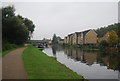
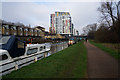
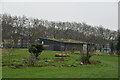
Lee Conservancy Road
The River Lee Navigation is on the other side of these houses and flats, hence the name of the road. Mabley Green is to the right. This is the view from Homerton Road.
Image: © Marathon
Taken: 19 Nov 2014
0.04 miles
3
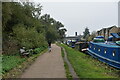
National Cycle Route 1 along Lea Navigation
Image: © N Chadwick
Taken: 21 Nov 2019
0.05 miles
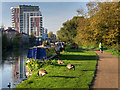
5
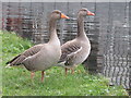
Greylag geese on the river
Two Greylag geese adjacent to the River Lea, a short distance from the Olympic Stadium.
Image: © Dave Pickersgill
Taken: 30 Dec 2011
0.05 miles
10
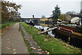
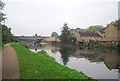
River Lee Navigation at Hackney Wick
The Lee Navigation is a canalised river incorporating the River Lea (also called the River Lee). It runs from Hertford Castle Weir to the River Thames at Bow Creek. Much of the Lee Navigation is within Lea Valley Park. The Lea Valley Walk, a 50-mile long-distance public walking path and bicycle trail from the headwaters to the Thames confluence, follows the canal towpaths in the Lee Navigation section.
https://canalrivertrust.org.uk/enjoy-the-waterways/canal-and-river-network/lee-navigation Canal and River Trust
https://en.wikipedia.org/wiki/Lee_Navigation Wikipedia
Image: © David Dixon
Taken: 31 Oct 2016
0.08 miles