IMAGES TAKEN NEAR TO
Victoria Park Road, LONDON, E9 5DY
Introduction
This page details the photographs taken nearby to Victoria Park Road, E9 5DY by members of the Geograph project.
The Geograph project started in 2005 with the aim of publishing, organising and preserving representative images for every square kilometre of Great Britain, Ireland and the Isle of Man.

There are currently over 7.5m images from over14,400 individuals and you can help contribute to the project by visiting https://www.geograph.org.uk
Image Map (Loading...)


Getting Data...Please wait
Leaflet Map data © OpenStreetMap
Images are licensed for reuse under creativecommons.org/licenses/by-sa/2.0
Notes
- Clicking on the map will re-center to the selected point.
- The higher the marker number, the further away the image location is from the centre of the postcode.
Image Listing (70 Images Found)
Images are licensed for reuse under creativecommons.org/licenses/by-sa/2.0
Image
Details
Distance
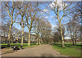
3
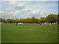
Sunday morning football at Victoria Park
The larger eastern part of the park has all the football pitches. The houses in the distance are in Victoria Park Road.
Image: © Kenneth Yarham
Taken: 24 Oct 2004
0.06 miles
4
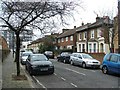
Victoria Park, London E9
Looking north from the park towards Victoria Park Road. The 388 bus is heading west, bound for Bethnal Green and Blackfriars.
Image: © John Davies
Taken: 14 Dec 2005
0.06 miles
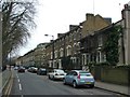
6
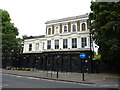
The People's Park Tavern
On Victoria Park Road (A106), London, E9.
Image: © JThomas
Taken: 22 Aug 2022
0.07 miles